Tradersville, Ohio
| Tradersville, Ohio | |
|---|---|
| Unincorporated community | |
 Tradersville, Ohio Location of Tradersville, Ohio | |
| Coordinates: 39°59′59″N 83°29′55″W / 39.99972°N 83.49861°W | |
| Country | United States |
| State | Ohio |
| Counties | Madison |
| Elevation[1] | 1,102 ft (336 m) |
| Time zone | UTC-5 (Eastern (EST)) |
| • Summer (DST) | UTC-4 (EDT) |
| ZIP code | 43140 |
| Area code(s) | 740 |
| GNIS feature ID | 1047126[1] |
Tradersville is an unincorporated community in Somerford Township, Madison County, Ohio, United States. It is located at 39°59′59″N 83°29′55″W / 39.99972°N 83.49861°WCoordinates: 39°59′59″N 83°29′55″W / 39.99972°N 83.49861°W,[2] at the intersection of Ohio State Route 187 and Tradersville-Brighton Road, about three miles north of Choctaw Lake.
As of 1875, Tradersville contained one dry goods and grocery store, a post office, and a blacksmith shop.[3]
The Tradersville Post office was established on March 2, 1848 and discontinued on January 19, 1883. It was then reestablished on January 24, 1900, and discontinued yet again on August 31, 1901. The mail service is now sent through the London branch.[4]
References
- 1 2 "US Board on Geographic Names". United States Geological Survey. 2007-10-25. Retrieved 2008-01-31.
- ↑ U.S. Geological Survey Geographic Names Information System: Tradersville, Ohio
- ↑ J. A. Caldwell, Caldwell's Atlas of Madison County, Ohio, Condit, Ohio, 1875, Pg. 10.
- ↑ U.S. Geological Survey Geographic Names Information System: Tradersville Post Office
Municipalities and communities of Madison County, Ohio, United States | ||
|---|---|---|
| City | 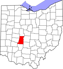 | |
| Villages | ||
| Townships | ||
| CDPs | ||
| Unincorporated communities | ||
| Footnotes | ‡This populated place also has portions in an adjacent county or counties | |
This article is issued from
Wikipedia.
The text is licensed under Creative Commons - Attribution - Sharealike.
Additional terms may apply for the media files.