Torraccia
| Torraccia | |
|---|---|
| Village | |
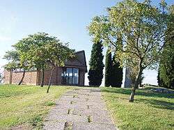 Village church of Torraccia | |
 Location of Domagnano within San Marino | |
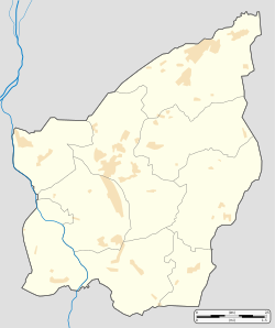 Torraccia Location within San Marino | |
| Coordinates: 43°57′11.6″N 12°30′26.4″E / 43.953222°N 12.507333°E | |
| Country |
|
| Municipality |
|
| Elevation | 250 m (820 ft) |
| Population (2003) | |
| • Total | 150 |
| Demonym(s) | torraccesi |
| Time zone | UTC+1 (CET) |
| • Summer (DST) | UTC+2 (CEST) |
| Postal code | 47895 |
| Area code(s) | +378 (0549) |
Torraccia is a small village (curazia) located in San Marino. It belongs to the municipality (castello) of Domagnano.
Geography
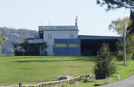
Torraccia airfield
Torraccia is situated in the east of Domagnano, close to the borders with the Italian municipality of Coriano, in the Province of Rimini. It is principally crossed by two roads named Strada di Montelupo and Strada di Monte Olivo. This one links the village to Domagnano, Fiorina and Serravalle.
In the south of the village, in the locality of Montelupo, it is located the Torraccia airfield coordinates: 43°56′50″N 12°30′30″E / 43.94722°N 12.50833°E), the only airfield in San Marino. It is owned by the AeroClub San Marino (ACS).[1]
See also
References
- ↑ (in Italian) AeroClub San Marino official site

This article is issued from
Wikipedia.
The text is licensed under Creative Commons - Attribution - Sharealike.
Additional terms may apply for the media files.