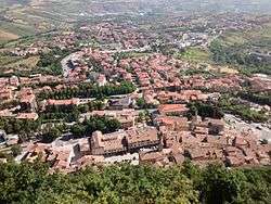
Borgo Maggiore
| Borgo Maggiore | |||
|---|---|---|---|
| castello | |||
 | |||
| |||
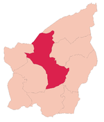 Borgo Maggiore's location in San Marino | |||
 Borgo Maggiore Borgo Maggiore's location in San Marino | |||
| Coordinates: 43°56′42.08″N 12°26′59″E / 43.9450222°N 12.44972°E | |||
| Country |
| ||
| Government | |||
| • Capitano | Sergio Nanni (since 2007) | ||
| Area | |||
| • Total | 9.01 km2 (3.48 sq mi) | ||
| Elevation | 525 m (1,722 ft) | ||
| Population (May 2018) | |||
| • Total | 6,871[1] | ||
| Time zone | UTC+1 (CET) | ||
| • Summer (DST) | CEST | ||
| Postal code | 47893 | ||
| Climate | Cfb | ||
Borgo Maggiore is one of the 9 communes or "castelli" of San Marino. It lies at the foot of Monte Titano and has a population of 6,871 (May 2018)[1], making it the second largest town of San Marino, after Dogana.
Geography
It borders the San Marino municipalities Serravalle, Domagnano, Faetano, Fiorentino, San Marino City, and Acquaviva and the Italian municipality Verucchio.
History
The area was previously called Mercatale ("marketplace") and remains today the most important market town in San Marino. A cable car allows Monte Titano to be scaled up to the town of San Marino. Today Borgo Maggiore contains the nation's only heliport. Though it is not the most populated, the Market, as well as the connection to San Marino City, make it very much a city-like shopping hub.
Parishes
Borgo Maggiore has 6 parishes (curazie):
Points of interest
- Piazza Grande, town square
- Only heliport in San Marino
Notable inhabitants
- Alessandra Perilli (born 1988), Sanmarinese sport shooter
- Manuel Poggiali (born 1983), Sanmarinese motorcycle racer
References
External links
![]()
Coordinates: 43°56′42.08″N 12°26′59″E / 43.9450222°N 12.44972°E
| Authority control |
|---|