Topdalsfjorden
| Topdalsfjorden | |
|---|---|
| Tofdalsfjorden / Tovdalsfjorden | |
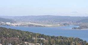 View of the fjord in Kristiansand | |
 Topdalsfjorden Location of the fjord  Topdalsfjorden Topdalsfjorden (Norway) | |
| Location | Vest-Agder county, Norway |
| Coordinates | 58°09′24″N 8°02′49″E / 58.1566°N 08.0469°ECoordinates: 58°09′24″N 8°02′49″E / 58.1566°N 08.0469°E |
| Type | Fjord |
| Primary inflows | Tovdalselva |
| Primary outflows | Østergapet |
| Basin countries | Norway |
| Max. length | 12 kilometres (7.5 mi) |
| Settlements | Kristiansand |
Topdalsfjorden or Tofdalsfjorden is a fjord in the municipality of Kristiansand in Vest-Agder county, Norway. The 12-kilometre (7.5 mi) long fjord runs from the village of Ålefjær south to the city centre of Kristiansand. The river Topdalselva empties into the fjord at the eastern side just south of the Kristiansand Airport, Kjevik. The European route E18 highway crosses the fjord on the Varodd Bridge.[1][2][3]
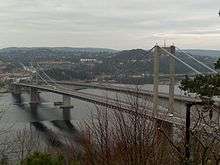
Topdalsfjorden is crossed by the Varodd Bridge.
References
- ↑ Evensen, Knut Harald, ed. (2010). NAF Veibok 2010–2012 (in Norwegian) (29 ed.). Oslo: Norges Automobil-Forbund. p. 14.
- ↑ Godal, Anne Marit (ed.). "Tovdalsvassdraget". Store norske leksikon (in Norwegian). Oslo: Norsk nettleksikon. Retrieved 13 August 2013.
- ↑ Godal, Anne Marit (ed.). "Kristiansand". Store norske leksikon (in Norwegian). Oslo: Norsk nettleksikon. Retrieved 13 August 2013.
This article is issued from
Wikipedia.
The text is licensed under Creative Commons - Attribution - Sharealike.
Additional terms may apply for the media files.