Threatt Filling Station
|
Threatt Filling Station | |
 | |
 | |
| Nearest city | Luther, Oklahoma |
|---|---|
| Coordinates | 35°39′59″N 97°08′28″W / 35.66639°N 97.14111°WCoordinates: 35°39′59″N 97°08′28″W / 35.66639°N 97.14111°W |
| Area | less than one acre |
| Built | c.1915 |
| Built by | Threatt, Allen |
| Architectural style | Bungalow/craftsman |
| MPS | Route 66 in Oklahoma MPS |
| NRHP reference # | 95000038[1] |
| Added to NRHP | February 23, 1995 |
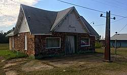
The Threatt Filling Station, at the southwestern corner of the former U.S. Route 66 and Pottawatomi Rd. about 3 miles (4.8 km) east of Luther, Oklahoma (which is about 20 miles (32 km) east of Oklahoma), is a filling station built around 1915. It was listed on the National Register of Historic Places in 1995.[1]
It is "an example of a 'house' type of station, designed in the Bungalow/Craftsman style of architecture."[2]
Its original c.1915 gas pumps had glass globes on top so that the amount of gasoline to be dispensed could be determined, but those were replaced by two c.1940 pumps.[2]
References
- 1 2 National Park Service (2013-11-02). "National Register Information System". National Register of Historic Places. National Park Service.
- 1 2 Maryjo Meacham; Brenda Peck; Lisa Bradley; Susan Roth (May 31, 1992). "National Register of Historic Places Registration: Threatt Filling Station". National Park Service. Retrieved July 20, 2018. With accompanying two photos from 1991
| Topics | |
|---|---|
| Lists by states |
|
| Lists by insular areas | |
| Lists by associated states | |
| Other areas | |
| |
This article is issued from
Wikipedia.
The text is licensed under Creative Commons - Attribution - Sharealike.
Additional terms may apply for the media files.