Thornville, Ohio
| Thornville, Ohio | |
|---|---|
| Village | |
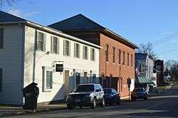 Columbus Street downtown | |
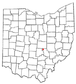 Location of Thornville, Ohio | |
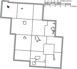 Location of Thornville in Perry County | |
| Coordinates: 39°53′47″N 82°25′10″W / 39.89639°N 82.41944°WCoordinates: 39°53′47″N 82°25′10″W / 39.89639°N 82.41944°W | |
| Country | United States |
| State | Ohio |
| County | Perry |
| Area[1] | |
| • Total | 1.10 sq mi (2.85 km2) |
| • Land | 1.10 sq mi (2.85 km2) |
| • Water | 0 sq mi (0 km2) |
| Elevation[2] | 1,030 ft (314 m) |
| Population (2010)[3] | |
| • Total | 991 |
| • Estimate (2012[4]) | 995 |
| • Density | 900.9/sq mi (347.8/km2) |
| Time zone | UTC-5 (Eastern (EST)) |
| • Summer (DST) | UTC-4 (EDT) |
| ZIP code | 43076 |
| Area code(s) | 740 |
| FIPS code | 39-76680[5] |
| GNIS feature ID | 1049246[2] |
| Website | www.thornville.us |
Thornville is a village in Perry County, Ohio, United States. The population was 991 at the 2010 census.
History
Thornville was originally called Lebanon, and under the latter name was laid out around 1811.[6] A post office called Thornville has been in operation since 1820.[7]
Geography
Thornville is located at 39°53′47″N 82°25′10″W / 39.89639°N 82.41944°W (39.896506, -82.419563).[8]
According to the United States Census Bureau, the village has a total area of 1.10 square miles (2.85 km2), all land.[1]
Demographics
| Historical population | |||
|---|---|---|---|
| Census | Pop. | %± | |
| 1880 | 269 | — | |
| 1890 | 405 | 50.6% | |
| 1900 | 374 | −7.7% | |
| 1910 | 411 | 9.9% | |
| 1920 | 451 | 9.7% | |
| 1930 | 439 | −2.7% | |
| 1940 | 411 | −6.4% | |
| 1950 | 432 | 5.1% | |
| 1960 | 521 | 20.6% | |
| 1970 | 679 | 30.3% | |
| 1980 | 838 | 23.4% | |
| 1990 | 758 | −9.5% | |
| 2000 | 731 | −3.6% | |
| 2010 | 991 | 35.6% | |
| Est. 2017 | 999 | [9] | 0.8% |
| U.S. Decennial Census[10] | |||
2010 census
As of the census[3] of 2010, there were 991 people, 417 households, and 277 families residing in the village. The population density was 900.9 inhabitants per square mile (347.8/km2). There were 447 housing units at an average density of 406.4 per square mile (156.9/km2). The racial makeup of the village was 98.8% White, 0.1% African American, 0.1% Native American, 0.1% Asian, and 0.9% from two or more races.
There were 417 households of which 34.3% had children under the age of 18 living with them, 48.9% were married couples living together, 11.5% had a female householder with no husband present, 6.0% had a male householder with no wife present, and 33.6% were non-families. 27.8% of all households were made up of individuals and 12.7% had someone living alone who was 65 years of age or older. The average household size was 2.38 and the average family size was 2.87.
The median age in the village was 39.7 years. 25.1% of residents were under the age of 18; 8.1% were between the ages of 18 and 24; 24.2% were from 25 to 44; 26.9% were from 45 to 64; and 16% were 65 years of age or older. The gender makeup of the village was 47.8% male and 52.2% female.
2000 census
As of the census[5] of 2000, there were 731 people, 282 households, and 212 families residing in the village. The population density was 1,686.7 people per square mile (656.4/km²). There were 298 housing units at an average density of 687.6 per square mile (267.6/km²). The racial makeup of the village was 98.91% White, 0.41% Native American, and 0.68% from two or more races.
There were 282 households out of which 35.1% had children under the age of 18 living with them, 66.0% were married couples living together, 6.4% had a female householder with no husband present, and 24.5% were non-families. 22.0% of all households were made up of individuals and 10.3% had someone living alone who was 65 years of age or older. The average household size was 2.59 and the average family size was 3.03.
In the village, the population was spread out with 26.0% under the age of 18, 6.3% from 18 to 24, 31.1% from 25 to 44, 23.3% from 45 to 64, and 13.4% who were 65 years of age or older. The median age was 38 years. For every 100 females there were 98.6 males. For every 100 females age 18 and over, there were 96.7 males.
The median income for a household in the village was $47,679, and the median income for a family was $51,641. Males had a median income of $34,107 versus $30,694 for females. The per capita income for the village was $18,922. About 1.8% of families and 4.2% of the population were below the poverty line, including 4.0% of those under age 18 and 6.8% of those age 65 or over.
Education
Northern Local School District operates three public schools in the village: Thornville Elementary School, Sheridan Middle School, and Sheridan High School.[11]
Thornville has a public library, a branch of the Perry County District Library.[12]
References
- 1 2 "US Gazetteer files 2010". United States Census Bureau. Archived from the original on 2012-01-24. Retrieved 2013-01-06.
- 1 2 "US Board on Geographic Names". United States Geological Survey. 2007-10-25. Retrieved 2008-01-31.
- 1 2 "American FactFinder". United States Census Bureau. Retrieved 2013-01-06.
- ↑ "Population Estimates". United States Census Bureau. Archived from the original on 2013-06-17. Retrieved 2013-06-17.
- 1 2 "American FactFinder". United States Census Bureau. Retrieved 2008-01-31.
- ↑ Colborn, Ephraim S. (1883). History of Fairfield and Perry Counties, Ohio. Brookhaven Press. p. 315.
- ↑ "Perry County". Jim Forte Postal History. Retrieved 17 December 2015.
- ↑ "US Gazetteer files: 2010, 2000, and 1990". United States Census Bureau. 2011-02-12. Retrieved 2011-04-23.
- ↑ "Population and Housing Unit Estimates". Retrieved May 26, 2018.
- ↑ "Census of Population and Housing". Census.gov. Retrieved June 4, 2015.
- ↑ "Our schools". Northern Local School District. Retrieved 3 March 2018.
- ↑ "Hours and locations". Perry County District Library. Retrieved 3 March 2018.
External links
Municipalities and communities of Perry County, Ohio, United States | ||
|---|---|---|
| Villages |  | |
| Townships | ||
| CDPs | ||
| Unincorporated communities | ||
| Ghost towns | ||
| Footnotes | ‡This populated place also has portions in an adjacent county or counties | |