Monroe Township, Perry County, Ohio
| Monroe Township, Perry County, Ohio | |
|---|---|
| Township | |
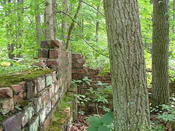 Ruins at San Toy | |
 Location of Monroe Township in Perry County | |
| Coordinates: 39°36′4″N 82°5′13″W / 39.60111°N 82.08694°WCoordinates: 39°36′4″N 82°5′13″W / 39.60111°N 82.08694°W | |
| Country | United States |
| State | Ohio |
| County | Perry |
| Area | |
| • Total | 33.6 sq mi (87.1 km2) |
| • Land | 33.5 sq mi (86.9 km2) |
| • Water | 0.1 sq mi (0.2 km2) |
| Elevation[1] | 745 ft (227 m) |
| Population (2000) | |
| • Total | 1,565 |
| • Density | 46.7/sq mi (18.0/km2) |
| Time zone | UTC-5 (Eastern (EST)) |
| • Summer (DST) | UTC-4 (EDT) |
| FIPS code | 39-51520[2] |
| GNIS feature ID | 1086786[1] |
Monroe Township is one of the fourteen townships of Perry County, Ohio, United States. The 2000 census found 1,565 people in the township, 926 of whom lived in the unincorporated portions of the township.[3]
Communities
- Corning is a village located at 39°36′17″N 82°5′17″W / 39.60472°N 82.08806°W within the northern portion of the township.
- Rendville is a village located at 39°37′2″N 82°5′22″W / 39.61722°N 82.08944°W within the northern portion of the township.The population was 36 at the 2010 census,[4] making it the smallest incorporated community in Ohio.[5]
Geography
Located in the southeastern corner of the county, it borders the following townships:
- Bearfield Township - north
- Deerfield Township, Morgan County - northeast corner
- Union Township, Morgan County - east
- Homer Township, Morgan County - southeast corner
- Trimble Township, Athens County - south
- Coal Township - southwest
- Salt Lick Township - west
- Pleasant Township - northwest
Name and history
Monroe Township was organized in 1823, and named for President James Monroe.[6] It is one of twenty-two Monroe Townships statewide.[7]
Government
The township is governed by a three-member board of trustees, who are elected in November of odd-numbered years to a four-year term beginning on the following January 1. Two are elected in the year after the presidential election and one is elected in the year before it. There is also an elected township fiscal officer,[8] who serves a four-year term beginning on April 1 of the year after the election, which is held in November of the year before the presidential election. Vacancies in the fiscal officership or on the board of trustees are filled by the remaining trustees.
References
- 1 2 "US Board on Geographic Names". United States Geological Survey. 2007-10-25. Retrieved 2008-01-31.
- ↑ "American FactFinder". United States Census Bureau. Retrieved 2008-01-31.
- ↑ Perry County, Ohio — Population by Places Estimates Ohio State University, 2007. Accessed 15 May 2007.
- ↑ "Profile of General Population and Housing Characteristics: 2010 Demographic Profile Data (DP-1): Rendville village, Ohio". U.S. Census Bureau, American Factfinder. Retrieved June 1, 2012.
- ↑ "Age Groups and Sex: 2010 - State -- Place 2010 Census Summary File 1 (GCT-P2): Ohio". U.S. Census Bureau, American Factfinder. Retrieved June 1, 2012.
- ↑ Colborn, Ephraim S. (1883). History of Fairfield and Perry Counties, Ohio. Brookhaven Press. p. 219.
- ↑ "Detailed map of Ohio" (PDF). United States Census Bureau. 2000. Retrieved 2007-02-16.
- ↑ §503.24, §505.01, and §507.01 of the Ohio Revised Code. Accessed 4/30/2009.
External links
Municipalities and communities of Perry County, Ohio, United States | ||
|---|---|---|
| Villages | 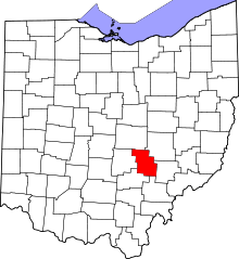 | |
| Townships | ||
| CDPs | ||
| Unincorporated communities | ||
| Ghost towns | ||
| Footnotes | ‡This populated place also has portions in an adjacent county or counties | |