Thomas Bernard Collinson
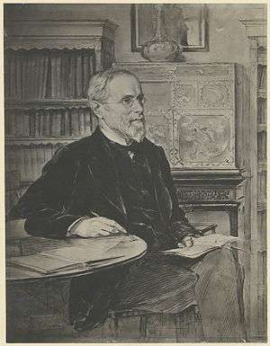
Major General Thomas Bernard Collinson (18 November 1821 – 1 May 1902) was an English naval surveyor of the Royal Engineers who carried out the earliest British surveys of Hong Kong and planned roads and other early military and civil engineering works in New Zealand. Immediately prior to retirement, he was architect to the Scottish Prison Commission.
Origin and military service
Collinson was born in Gateshead, Tyne and Wear, England, then part of County Durham, ninth child of Rev. John Collinson, Rector of Gateshead.[1] He joined the Royal Navy in 1838, spending his first five years in ordnance survey work in Wales, Ireland and Northern England. His service over the years before his retirement with the rank of major-general, in 1873, took him to Hong Kong, Sydney, Auckland, Wellington, Wanganui, Hobart Town, Waltham, Aldershot, Corfu, Malta, Chatham, and Dover.[2] He was the younger brother of Sir Richard Collinson who pioneered coastal surveys of southern China.
Surveying Hong Kong
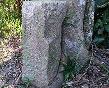
Given the task of mapping Hong Kong, from 1843 to 1845, Collinson established 27 trigonometric stations around Hong Kong Island in order to produce the first set of scientifically surveyed maps of Hong Kong, the Ordnance Map of Hong Kong published by the Board of Ordnance in 1845. Collinson used the French contour mapping method of which he was an early proponent. Only one stone station marker now remains, revealed by a University of Hong Kong team on 3 October 2015, at Lei Yue Mun Park.[3][4]
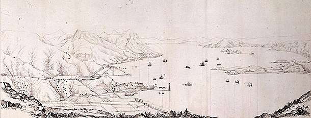
Collinson made the first records of many place names, including prominent locations in today's Hong Kong: Shek O, Chai Wan, Shau Kei Wan, Quarry Bay, Tai Tam, Tin Wan, Wan Chai, and Pok Fu Lam. Cape Collinson, Mount Collinson, Collinson Street, Cape Collinson Road and Path, on Hong Kong Island, were all named in his honour.[5] He also produced early detailed sketches of Hong Kong.[6]:25
New Zealand
On 11 June 1846, Collinson embarked on the Emily Jane for Sydney, New South Wales, and after a brief stay there, he sailed for Auckland, New Zealand, on the trading brigantine Terror, arriving on 19 September 1846 to difficult times of conflict between the Pakeha settlers and the native Māori population. By November, he had sailed for Wellington and then spent over three years working on military buildings and defences there and in Wanganui before his return to England via Hobart Town in 1850.[7] Collinson was a keen illustrator and many examples, some featuring Māori, are kept at the Alexander Turnbull Library of the National Library of New Zealand.[8]
Death
Collison died on 1 May 1902 at Ealing. He was a wealthy man, leaving an estate of £20,534 10s 8d.[7]
References
- ↑ Davies, Stephen (2012). Dictionary of Hong Kong Biography. Hong Kong University Press. p. 107.
- ↑ Proceedings of the Institution of Civil Engineers, Vol 150. Institution of Civil Engineers. 1902.
- ↑ Nip, Amy (16 December 2015). "HKU students discover old boundary stone in park". The Standard. Retrieved 17 December 2015.
- ↑ Cheng, Kris (17 December 2015). "HKU urges heritage status for oldest boundary stone ever discovered in Hong Kong". Hong Kong Free Press. Retrieved 17 December 2015.
- ↑ Yanne, Andrew; Heller, Gillis (2009). Signs of a Colonial Era. Hong Kong University Press. ISBN 978-9622099449.
- ↑ Nicholson, Ken (2010). The Happy Valley. The Hong Kong University Press. ISBN 978-9888028108.
- 1 2 Heath, Philip. "Thomas Bernard Collinson". Retrieved 18 December 2015.
- ↑ "Thomas Bernard Collinson". National Library of New Zealand. Retrieved 18 December 2015.