Thiel Mountains
| Thiel Mountains | |
|---|---|
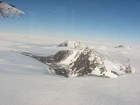 Aerial view of the Thiel Mountains | |
| Highest point | |
| Peak | Anderson Summit[1] |
| Elevation | 2,810 m (9,220 ft) |
| Coordinates | 85°3′S 90°51′W / 85.050°S 90.850°WCoordinates: 85°3′S 90°51′W / 85.050°S 90.850°W |
| Dimensions | |
| Length | 72 km (45 mi) |
| Area | 71,578 km2 (27,636 sq mi) |
| Geography | |
 Thiel Mountains Location in Antarctica | |
| Continent | Antarctica |
| Region | Ellsworth Land |
| Parent range | Transantarctic Mountains |
| Borders on | Horlick Mountains and Pensacola Mountains |
| Thiel Mountains Skiway | |||||||||||
|---|---|---|---|---|---|---|---|---|---|---|---|
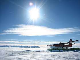 Thiel Mauntains refueling depot | |||||||||||
| Summary | |||||||||||
| Airport type | Private | ||||||||||
| Location |
Thiel Mountains Ellsworth Land | ||||||||||
| Coordinates | 85°11′54″S 87°52′42″W / 85.198333°S 87.878333°W | ||||||||||
| Map | |||||||||||
 Thiel Mountains Skiway Location of airfield in Antarctica | |||||||||||
| Runways | |||||||||||
| |||||||||||
The Thiel Mountains are an isolated, mainly snow-capped mountain range of the Transantarctic Mountains System, located in the Ellsworth Land region of Antarctica
The mountain range is 72 km (45 mi) long, and is located roughly between the Horlick Mountains and the Pensacola Mountains, and extends from Moulton Escarpment on the west to Nolan Pillar on the east.
Major components include Ford Massif (2,810 m), Bermel Escarpment and a group of eastern peaks near Nolan Pillar. The mountains were observed and first positioned by the USARP Horlick Mountains Traverse Party, 1958-59. The mountains were surveyed by the USGS Thiel Mountains parties of 1960-61 and 1961-62.[2]
The Thiel Mountains were named by US-ACAN after Dr. Edward C. Thiel, traverse seismologist at Ellsworth Station and the Pensacola Mountains in 1957. In December 1959, he made airlifted geophysical observations along the 88th meridian west, including work near these mountains. Thiel perished with four others on November 9, 1961 in the crash of a P2V Neptune aircraft soon after take-off from Wilkes Station.[2]
An aircraft fuel cache (85°12′S 087°53′W / 85.200°S 87.883°W) is located near the Thiel Mountains for planes traveling between the Union Glacier Camp and the Amundsen–Scott South Pole Station.[3]
Gallery
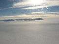 Distant aerial view of the Thiel Mountains
References
- ↑ "Thiel Mountains". Peakbagger. Retrieved 23 May 2017.
- 1 2 U.S. Geological Survey Geographic Names Information System: Thiel Mountains
- ↑ South Pole Flights
| General |
| .svg.png) |
|---|---|---|
| Geographic regions | ||
| Waterways | ||
| Famous explorers | ||