Salle, Norfolk
| Salle | |
|---|---|
 Salle church, behind the cricket ground | |
 Salle Salle shown within Norfolk | |
| Area | 8.21 km2 (3.17 sq mi) |
| Population | 50 |
| • Density | 6/km2 (16/sq mi) |
| OS grid reference | TG109248 |
| Civil parish |
|
| District | |
| Shire county | |
| Region | |
| Country | England |
| Sovereign state | United Kingdom |
| Post town | NORWICH |
| Postcode district | NR10 |
| Police | Norfolk |
| Fire | Norfolk |
| Ambulance | East of England |
| EU Parliament | East of England |
Salle (/ˈsɔːl/ SAWL)[1] is a village and civil parish in the English county of Norfolk. It is around 10 miles (16 km) north-west of Norwich in Broadland district. The village, which is pronounced Saul, gets its name from "Sallow Wood", Sallow referring to Willow in Norfolk.[2]
The civil parish has an area of 8.21 square kilometres (3.17 sq mi) and in 2001 had a population of 50 in 21 households.[3]
Salle is celebrated for its fine, huge late medieval church, which retains the lower part of its rood screen.
St Peter and St Paul's Church
The church, which dates from the first part of the 15th century, is an exceptionally complete Perpendicular building.[4] It is huge for the size of the village - several lords of local manors, including the Boleyn family, vied with each other to fund the building of the church. There are many brasses, including to members of the Boleyn family.
The church retains some of its medieval stained glass in the east window and in the south transept south window, and there is a 15th-century pulpit. The font has a tall, extravagant Perpendicular style canopy, with a lifting crane sprung from the ringing gallery.[5]
The 130 feet tower faced with Barnack stone and flint has been described as "the most perfectly composed of all late medieval Norfolk towers", and as "one of the first of the great East Anglian towers".[6]
St Peter and St Paul's church was never collegiate, so it is peculiar that it has twenty six 15th century misericords. These are placed 13 on each side of the choir.
 View showing the belfry timbers, the font cover and general view east
 View west from sanctuary, showing misericords
 The fine Perpendicular style tower 130 feet tall.
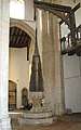 Font cover and crane
 15th Century pulpit.
 Roof detail.
Notes
- ↑ Rossiter, Stuart, ed. (1976). Blue Guide England. Ernest Benn. p. 461.
- ↑ History, Salle Farms Co, 2013. Retrieved 2016-11-04.
- ↑ Census population and household counts for unparished urban areas and all parishes Archived 2017-02-11 at the Wayback Machine.. Office for National Statistics & Norfolk County Council (2001). Retrieved 20 June 2009.
- ↑ Nikolaus Pevsner, Buildings of England, North-East Norfolk and Norwich, Penguin, 1962
- ↑ Norfolk Churches Retrieved 22 June 2014
- ↑ "Thames & Hudson Publishers | Essential illustrated art books | Fifty English Steeples | The Finest Medieval Parish Church Towers and Spires in England". www.thamesandhudson.com. Archived from the original on 2016-10-30. Retrieved 2017-10-23.
External links
| Wikimedia Commons has media related to Salle, Norfolk. |
| Wikimedia Commons has media related to Church of St Peter and St Paul, Salle. |
- Map sources for Salle, Norfolk