The Cupola (mountain)
| The Cupola | |
|---|---|
 | |
| Highest point | |
| Elevation | 970 m (3,180 ft) |
| Prominence | 650 m (2,130 ft) |
| Parent peak | Frankland Peak |
| Coordinates | 42°56′16″S 146°03′04″E / 42.93778°S 146.05111°ECoordinates: 42°56′16″S 146°03′04″E / 42.93778°S 146.05111°E [1] |
| Geography | |
 The Cupola Location in Tasmania | |
| Location | South West Tasmania |
| Parent range | Frankland Range |
| Topo map | Solitary[2] |
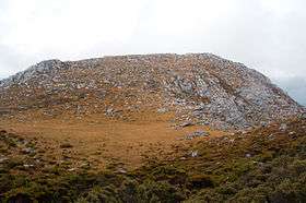
The Cupola is a mountain in the south-west region of Tasmania, Australia. Situated on the Frankland Range, The Cupola has an elevation of 970 metres (3,180 ft) above sea level and juts out from the range towards the impoundment Lake Pedder. The Redtop Peak is situated to the west of The Cupola.[3]
The mountain's name may derive from cupola, a dome-shaped ornamental structure located on top of a larger roof or dome.
See also
References
- ↑ "The Cupola (TAS)". Gazetteer of Australia online. Geoscience Australia, Australian Government.
- ↑ Solitary 4224 (Map) (1st ed.). 1:25000. Tasmania: Tasmap. 2001.
- ↑ "Map of The Cupola, TAS". Bonzle Digital Atlas of Australia. Retrieved 1 July 2015.
This article is issued from
Wikipedia.
The text is licensed under Creative Commons - Attribution - Sharealike.
Additional terms may apply for the media files.