Frankland Range
| Frankland Range | |
|---|---|
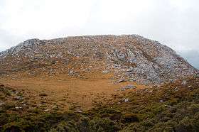 The Cupola, one of the peaks in the range. | |
| Highest point | |
| Peak | Frankland Peak |
| Elevation | 1,083 m (3,553 ft) [1] AHD |
| Coordinates | 42°58′48″S 146°08′24″E / 42.98000°S 146.14000°E [2] |
| Geography | |
 Location of the Frankland Range in Tasmania | |
| Country | Australia |
| State | Tasmania |
| Region | South West |
| Range coordinates | 42°59′S 146°09′E / 42.983°S 146.150°ECoordinates: 42°59′S 146°09′E / 42.983°S 146.150°E |
The Frankland Range is a mountain range that is located in the south-west region of Tasmania, Australia. The range forms part of a natural south-western border to the impounded Lake Pedder, formed by the damming of the Serpentine and Huon rivers.
As part of the South West Wilderness area, it is a less popular site of bushwalking than other, more famous, ranges in Tasmania's South West, and is for much more advanced walkers due to its length, isolation and terrain. Access routes to the range are by boat from the lake, or the roads at Strathgordon or Scotts Peak Dam.[3]
Nearby ranges include the Arthur, Companion, Folded, Tribulation, and the Wilmot ranges.
Notable peaks
See also
References
- 1 2 Solitary (Map) (1st ed.). 1:25000. Tasmania: Tasmap. 2001.
- 1 2 "Frankland Peak (TAS)". Gazetteer of Australia online. Geoscience Australia, Australian Government.
- ↑ Chapman, John. South West Tasmania (4th ed.). pp. 173–175.
- ↑ "The Cupola (TAS)". Gazetteer of Australia online. Geoscience Australia, Australian Government.
External links
- http://tqft.net/wiki/Frankland_Range
- "The Frankland Range: 26–31 January 2013". rockmonkeyadventures. January 2013.
This article is issued from
Wikipedia.
The text is licensed under Creative Commons - Attribution - Sharealike.
Additional terms may apply for the media files.