Sakhrai District
| Sakhrai สระใคร | |
|---|---|
| Amphoe | |
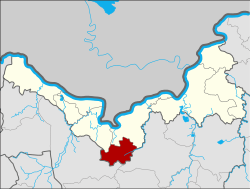 Amphoe location in Nong Khai Province | |
| Coordinates: 17°40′30″N 102°45′2″E / 17.67500°N 102.75056°ECoordinates: 17°40′30″N 102°45′2″E / 17.67500°N 102.75056°E | |
| Country | Thailand |
| Province | Nong Khai |
| Seat | Sakhrai |
| Area | |
| • Total | 210.90 km2 (81.43 sq mi) |
| Population (2005) | |
| • Total | 25,247 |
| • Density | 119.7/km2 (310/sq mi) |
| Time zone | UTC+7 (ICT) |
| Postal code | 43150 |
| Geocode | 4314 |
Sakhrai (Thai: สระใคร, pronounced [sàʔ.kʰrāj]) is a district (amphoe) of Nong Khai Province, northeastern Thailand.
History
The minor district (king amphoe) was split off from Mueang Nong Khai District on 30 April 1994.[1]
On 15 May 2007, all 81 minor districts were upgraded to full districts.[2] Publication in the Royal Gazette on 24 August the upgrade became official.[3]
Geography
Neighboring districts are (from the north clockwise) Tha Bo and Mueang Nong Khai of Nong Khai Province, and Phen and Ban Phue of Udon Thani Province.
Administration
The district is divided into three sub-districts (tambon), which are further subdivided into 39 villages (muban). There are no municipal (thesaban) areas. There are three tambon administrative organizations (TAO).
| No. | Name | Thai name | Villages | Pop. | |
|---|---|---|---|---|---|
| 1. | Sakhrai | สระใคร | 15 | 10,053 | |
| 2. | Khok Chang | คอกช้าง | 12 | 6,161 | |
| 3. | Ban Fang | บ้านฝาง | 12 | 8,994 |
Gallery
.jpg) Wat Salawan Nimit, Sakhrai
Wat Salawan Nimit, Sakhrai.jpg) Wat Salawan Nimit, Sakhrai
Wat Salawan Nimit, Sakhrai.jpg) Sakhrai
Sakhrai.jpg) Road in Sakhrai
Road in Sakhrai
References
- ↑ ประกาศกระทรวงมหาดไทย เรื่อง แบ่งเขตท้องที่อำเภอเมืองหนองคาย จังหวัดหนองคาย ตั้งเป็นกิ่งอำเภอสระใคร (PDF). Royal Gazette (in Thai). 111 (42 ง): 23. May 26, 1994.
- ↑ แถลงผลการประชุม ครม. ประจำวันที่ 15 พ.ค. 2550 (in Thai). Manager Online.
- ↑ พระราชกฤษฎีกาตั้งอำเภอฆ้องชัย...และอำเภอเหล่าเสือโก้ก พ.ศ. ๒๕๕๐ (PDF). Royal Gazette (in Thai). 124 (46 ก): 14–21. August 24, 2007.
External links
This article is issued from
Wikipedia.
The text is licensed under Creative Commons - Attribution - Sharealike.
Additional terms may apply for the media files.