Texas State Highway 42
| |||||||
|---|---|---|---|---|---|---|---|
 | |||||||
| Route information | |||||||
| Maintained by TxDOT | |||||||
| Length | 33.9 mi[1] (54.6 km) | ||||||
| Existed | 1962–present | ||||||
| Major junctions | |||||||
| South end |
| ||||||
|
| |||||||
| North end |
| ||||||
| Location | |||||||
| Counties | Rusk, Gregg | ||||||
| Highway system | |||||||
| |||||||

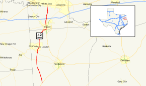
State Highway 42 is a state highway located in the northeastern portion of the Texas in Gregg and Rusk counties. This route was designated on December 12, 1962 over former SH 259 because of the creation of US 259 (which replaced cancelled SH 26) through Kilgore, which it intersected.
Previous routes

SH 42 was originally proposed on April 22, 1919 as a route from Greenville to Marshall.[2] On August 21, 1923, northwest terminus extended north to Sherman, replacing a section of SH 11.[3] The section of SH 42 from Alba to Marshall was cancelled. SH 42 was instead rerouted to end in Mineola. On January 21, 1924, the section from Alba to Mineola was cancelled. SH 42 was instead rerouted to end in Quitman.[4] On October 20, 1924, another section was created from Gilmer to Marshall, creating a gap.[5] On December 20, 1926, the gap was closed.[6] On MAy 9, 1927, SH 42 was truncated to Whitewright.[7] On February 24, 1930, its north end was truncated to Greenville.[8] on March 19, 1930, the route was rerouted southeast back to Mineola, while the section from Gilmer to Marshall was renumbered SH 155, the section from Alba to Gilmer was cancelled (Alba to Quitman would be restored as SH 182 in 1932).[9] On November 30, 1932, SH 42 extended north to Whitewright again.[10] On September 26, 1939, the entire remaining route was already part of U.S. Highway 69, so SH 42 was cancelled.
Counties and junctions
| County | Location | mi | km | Destinations | Notes |
|---|---|---|---|---|---|
| Rusk | | ||||
| Price | |||||
| | |||||
| | |||||
| New London | |||||
| South end of SH 135 overlap | |||||
| Laird Hill | |||||
| Kilgore | North end of SH 135 overlap | ||||
| South end of US 259 Bus. overlap | |||||
| Gregg | |||||
| North end of US 259 Bus. overlap | |||||
| I-20 exit 587; interchange. | |||||
| | |||||
| | |||||
| White Oak | |||||
| 1.000 mi = 1.609 km; 1.000 km = 0.621 mi | |||||
References
- ↑ Transportation Planning and Programming Division (n.d.). "State Highway No. 42". Highway Designation Files. Texas Department of Transportation. Retrieved 2010-11-01.
- ↑ (PDF) https://publicdocs.txdot.gov/minord/MinuteOrderDocLib/003676796.pdf. Missing or empty
|title=(help) - ↑ (PDF) https://publicdocs.txdot.gov/minord/MinuteOrderDocLib/003676878.pdf. Missing or empty
|title=(help) - ↑ (PDF) https://publicdocs.txdot.gov/minord/MinuteOrderDocLib/003676883.pdf. Missing or empty
|title=(help) - ↑ (PDF) https://publicdocs.txdot.gov/minord/MinuteOrderDocLib/003676893.pdf. Missing or empty
|title=(help) - ↑ (PDF) https://publicdocs.txdot.gov/minord/MinuteOrderDocLib/003676961.pdf. Missing or empty
|title=(help) - ↑ (PDF) https://publicdocs.txdot.gov/minord/MinuteOrderDocLib/003676975.pdf. Missing or empty
|title=(help) - ↑ (PDF) https://publicdocs.txdot.gov/minord/MinuteOrderDocLib/003673791.pdf. Missing or empty
|title=(help) - ↑ (PDF) https://publicdocs.txdot.gov/minord/MinuteOrderDocLib/003673792.pdf. Missing or empty
|title=(help) - ↑ (PDF) https://publicdocs.txdot.gov/minord/MinuteOrderDocLib/003673821.pdf. Missing or empty
|title=(help)