Texas State Highway 83
| ||||
|---|---|---|---|---|
 | ||||
| Route information | ||||
| Maintained by TxDOT | ||||
| Length | 56.07 mi[1] (90.24 km) | |||
| Existed | 1955–present | |||
| Major junctions | ||||
| West end |
| |||
|
| ||||
| East end |
| |||
| Highway system | ||||
| ||||

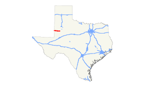
State Highway 83 (SH 83) is a state highway in the U.S. state of Texas that runs 56 miles (90 km) from the New Mexico border in Yoakum County east to Welch in northwest Dawson County.
History
The original SH 83 was designated on August 21, 1923 along a route from Lamesa east to an intersection with SH 18 in western Shackelford County as a renumbering of SH 18B.[2] On May 21, 1928, SH 83 extended west to the New Mexico border to connect with New Mexico Highway 83.[3] The route was transferred to SH 15 (now US 180) on August 8, 1935, though the change was not effective until September 1, 1935.[4] New Mexico Highway 83 was realigned in the 1950s, connecting with SH 328 instead. On March 31, 1955, SH 328 was renumbered to SH 83 "for the convenience of the traveling public" In 1988, the New Mexico connecting highway was renumbered New Mexico Highway 132.
Major intersections
| County | Location | mi[5] | km | Destinations[5] | Notes |
|---|---|---|---|---|---|
| Texas–New Mexico line | 0.0 | 0.0 | Continuation into New Mexico | ||
| Yoakum | | 10.2 | 16.4 | ||
| Denver City | 13.6 | 21.9 | |||
| 14.2 | 22.9 | Western terminus of concurrency with SH 214 | |||
| Gaines | | 15.7 | 25.3 | Eastern terminus of concurrency with SH 214 | |
| | 27.5 | 44.3 | |||
| Seagraves | 30.4 | 48.9 | |||
| 30.5 | 49.1 | ||||
| Loop | 38.9 | 62.6 | |||
| | 47.9 | 77.1 | |||
| Dawson | Welch | 55.7 | 89.6 | ||
| 56.1 | 90.3 | ||||
1.000 mi = 1.609 km; 1.000 km = 0.621 mi
| |||||
References
- ↑ Texas Department of Transportation,
- ↑ (PDF) https://publicdocs.txdot.gov/minord/MinuteOrderDocLib/003676878.pdf. Missing or empty
|title=(help) - ↑ (PDF) https://publicdocs.txdot.gov/minord/MinuteOrderDocLib/003673771.pdf. Missing or empty
|title=(help) - ↑ (PDF) https://publicdocs.txdot.gov/minord/MinuteOrderDocLib/003673871.pdf. Missing or empty
|title=(help) - 1 2 Google (January 21, 2016). "Texas State Highway 83" (Map). Google Maps. Google. Retrieved January 21, 2016.