Texas State Highway 67
| ||||
|---|---|---|---|---|
 | ||||
| Route information | ||||
| Maintained by TxDOT | ||||
| Length | 30.77 mi[1] (49.52 km) | |||
| Existed | 1923–present | |||
| Major junctions | ||||
| South end |
| |||
| North end |
| |||
| Location | ||||
| Counties | Stephens, Young | |||
| Highway system | ||||
| ||||

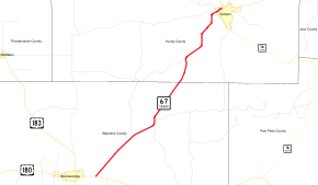
State Highway 67 or SH 67 is a Texas state highway that runs between Breckenridge and Graham.

The route was originally designated on August 21, 1923 along renumbered portions of SH 22 and SH 18, extending from Graham to Breckenridge, then southeast from Breckenridge, reaching the southern end of Waco.[2] On December 17, 1929, it was rerouted away from Carlton and through Clairette and Alexander instead.[3] On September 26, 1945 the section from Breckenridge to Waco was transferred to SH 6. Part became US 183 and SH 69 (later SH 112). On May 6, 1974, SH 67 was relocated in Graham over a new route and a portion of FM 61.
SH 67A was a spur which was designated on April 27, 1925 from SH 67 in Breckenridge to Woodson.[4] It was extended on January 16, 1928 to Throckmorton.[5] By 1930, this was renumbered as SH 157.
References
- ↑ Transportation Planning and Programming Division (n.d.). "State Highway No. 67". Highway Designation Files. Texas Department of Transportation.
- ↑ (PDF) https://publicdocs.txdot.gov/minord/MinuteOrderDocLib/003676878.pdf. Missing or empty
|title=(help) - ↑ (PDF) https://publicdocs.txdot.gov/minord/MinuteOrderDocLib/003673789.pdf. Missing or empty
|title=(help) - ↑ (PDF) https://publicdocs.txdot.gov/minord/MinuteOrderDocLib/003676904.pdf. Missing or empty
|title=(help) - ↑ (PDF) https://publicdocs.txdot.gov/minord/MinuteOrderDocLib/003676986.pdf. Missing or empty
|title=(help)