Texas State Highway 128
| ||||
|---|---|---|---|---|
 | ||||
| Route information | ||||
| Maintained by TxDOT | ||||
| Length | 13.769 mi[1] (22.159 km) | |||
| Existed | 1955–present | |||
| Major junctions | ||||
| West end |
| |||
| East end |
| |||
| Location | ||||
| Counties | Andrews | |||
| Highway system | ||||
| ||||

State Highway 128 (SH 128) is a state highway in Andrews County, Texas.[1]
Route description
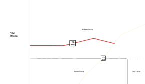
SH 128 begins at the New Mexico state line east of Jal, New Mexico, as New Mexico Highway 128 crosses into Texas. The route immediately encounters its only intersection between its termini, at FM 1218, which runs just inside the state line. The route travels eastward through unincorporated Andrews County before ending at SH 115 about 20 miles (32 km) southwest of Andrews.[2]
History
SH 128 was originally designated on May 21, 1927 along a route from Sinton northeast to the Victoria County Line. On October 11, 1927, it was extended south to Robstown and numbered SH 128.[3][4] On March 19, 1928, it extended north to Victoria.[5] On June 24, 1931, it had been extended west to Alice, replacing a portion of SH 12A.[6] On September 18, 1933, it extended north to Hallettsville.[7] On July 15, 1935, the section from Victoria to Hallettsville was cancelled.[8] On September 26, 1935, construction started the extension to Hallettsville, and this portion of SH 128 was restored as part of the lateral road program.[9] On November 24, 1936, the entire route became part of SH 44. It was then designated on the current SH 237 from La Grange northeast to US 290 near Carmine, replacing a portion of SH 72.[10] This was renumbered as SH 237 on December 22, 1936, probably to avoid confusion with the just cancelled SH 128.[11]

The current route was originally designated on May 7, 1948 as Farm to Market Road 781 and ran from the state line to FM 703.[12] The highway was signed, but not officially designated, concurrently as SH 128 beginning on March 30, 1955, "for guidance of traveling public" to correspond with New Mexico State Highway 128.[1] The FM 781 designation was cancelled on August 29, 1990; the same day, FM 703 became part of SH 115.[12][13]
Major intersections
The entire route is in Andrews County.
| Location | mi[14] | km | Destinations | Notes | |
|---|---|---|---|---|---|
| | 0.0 | 0.0 | Western terminus and continuation | ||
| | 0.0 | 0.0 | |||
| | 13.8 | 22.2 | Eastern terminus | ||
| 1.000 mi = 1.609 km; 1.000 km = 0.621 mi | |||||
References
- 1 2 3 Transportation Planning and Programming Division (n.d.). "State Highway No. 128". Highway Designation Files. Texas Department of Transportation. Retrieved June 15, 2010.
- ↑ Transportation Planning and Programming Division (2014). Texas County Mapbook (PDF) (Map) (2014 ed.). 1:120,000. Texas Department of Transportation. p. 76. Retrieved December 6, 2014.
- ↑ (PDF) https://publicdocs.txdot.gov/minord/MinuteOrderDocLib/003676983.pdf. Missing or empty
|title=(help) - ↑ (PDF) https://publicdocs.txdot.gov/minord/MinuteOrderDocLib/003676976.pdf. Missing or empty
|title=(help) - ↑ (PDF) https://publicdocs.txdot.gov/minord/MinuteOrderDocLib/003676989.pdf. Missing or empty
|title=(help) - ↑ (PDF) https://publicdocs.txdot.gov/minord/MinuteOrderDocLib/003673804.pdf. Missing or empty
|title=(help) - ↑ (PDF) https://publicdocs.txdot.gov/minord/MinuteOrderDocLib/003673835.pdf. Missing or empty
|title=(help) - ↑ (PDF) https://publicdocs.txdot.gov/minord/MinuteOrderDocLib/003673871.pdf. Missing or empty
|title=(help) - ↑ (PDF) https://publicdocs.txdot.gov/minord/MinuteOrderDocLib/003673874.pdf. Missing or empty
|title=(help) - ↑ (PDF) https://publicdocs.txdot.gov/minord/MinuteOrderDocLib/003673888.pdf. Missing or empty
|title=(help) - ↑ (PDF) https://publicdocs.txdot.gov/minord/MinuteOrderDocLib/003673889.pdf. Missing or empty
|title=(help) - 1 2 Transportation Planning and Programming Division (n.d.). "Farm to Market Road No. 781". Highway Designation Files. Texas Department of Transportation. Retrieved November 21, 2010.
- ↑ Transportation Planning and Programming Division (n.d.). "State Highway No. 115". Highway Designation Files. Texas Department of Transportation. Retrieved June 15, 2010.
- ↑ Google (September 26, 2011). "Overview map of Texas State Highway 128 Distances Between Interchanges" (Map). Google Maps. Google. Retrieved September 26, 2011.