Texas State Highway 127
| ||||
|---|---|---|---|---|
 | ||||
| Route information | ||||
| Maintained by TxDOT | ||||
| Length | 21.217 mi[1] (34.145 km) | |||
| Existed | before 1939–present | |||
| Major junctions | ||||
| South end |
| |||
| North end |
| |||
| Location | ||||
| Counties | Uvalde | |||
| Highway system | ||||
| ||||

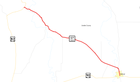
State Highway 127 (SH 127) is a state highway in Uvalde County in the U.S. state of Texas that connects Sabinal and Concan in south Texas.[1]
Route description
SH 127 begins in Sabinal at an intersection with US 90 and RM 187.[2] The highway travels north through Sabinal along Center Street, concurrent with RM 187, before separating from that route and turning toward the northwest. After crossing the Sabinal River, the highway travels through unincorporated Uvalde County, intersecting FM 30, FM 1049, and FM 2690.[3] The route crosses the Frio River at Concan before ending at a junction with US 83.[4]
History
The original SH 127 was designated on October 10, 1927[5][6] as a route from Cotulla eastward through Tilden to Oakville. It was officially numbered SH 127 on November 15, 1927.[7] On August 6, 1929, it extended northwest to SH 85 This route was cancelled on October 22, 1930, because La Salle county couldn't join the state to construct SH 2, so it was cancelled. This route was mostly restored starting in 1933-1934 as SH 202. The current route of SH 127 was then proposed on June 11, 1932.[8]
Major intersections
The entire route is in Uvalde County.
| Location | mi[9] | km | Destinations | Notes | |
|---|---|---|---|---|---|
| Sabinal | 0.0 | 0.0 | Southern terminus; south end of RM 187 concurrency | ||
| | 1.2 | 1.9 | North end of RM 187 concurrency | ||
| | 3.1 | 5.0 | |||
| | 12.4 | 20.0 | |||
| | 16.0 | 25.7 | |||
| Concan | 21.2 | 34.1 | Northern terminus | ||
| 1.000 mi = 1.609 km; 1.000 km = 0.621 mi | |||||
References
- 1 2 Transportation Planning and Programming Division (n.d.). "State Highway No. 127". Highway Designation Files. Texas Department of Transportation. Retrieved 2010-06-15.
- ↑ Transportation Planning and Programming Division (2012). Texas County Mapbook (PDF) (Map) (2012 ed.). 1:120,000. Texas Department of Transportation. p. 346. OCLC 867856197. Retrieved 2011-09-26.
- ↑ Transportation Planning and Programming Division (2012). Texas County Mapbook (PDF) (Map) (2012 ed.). 1:120,000. Texas Department of Transportation. p. 345. OCLC 867856197. Retrieved 2011-09-26.
- ↑ Transportation Planning and Programming Division (2012). Texas County Mapbook (PDF) (Map) (2012 ed.). 1:120,000. Texas Department of Transportation. p. 319. OCLC 867856197. Retrieved 2011-09-26.
- ↑ (PDF) https://publicdocs.txdot.gov/minord/MinuteOrderDocLib/003676983.pdf. Missing or empty
|title=(help) - ↑ Official Map of the Highway System of Texas (Map). Texas State Highway Department (Texas Department of Transportation). 1928. Archived from the original on 2012-05-10.
- ↑ (PDF) https://publicdocs.txdot.gov/minord/MinuteOrderDocLib/003676984.pdf. Missing or empty
|title=(help) - ↑ (PDF) https://publicdocs.txdot.gov/minord/MinuteOrderDocLib/003673815.pdf. Missing or empty
|title=(help) - ↑ Google (2011-09-26). "Overview map of Texas State Highway 127 Distances Between Interchanges" (Map). Google Maps. Google. Retrieved 2011-09-26.