Tennessee State Route 156
| ||||
|---|---|---|---|---|
| Route information | ||||
| Maintained by TDOT | ||||
| Length | 35.4 mi (57.0 km) | |||
| Major junctions | ||||
| North end |
| |||
|
| ||||
| East end |
| |||
| Location | ||||
| Counties | Franklin, Marion | |||
| Highway system | ||||
| ||||

State Route 156 (SR 156) is a spur route of SR 56 and a state highway in the southern central and southeastern portions of the U.S. state of Tennessee. It traverses the southern Cumberland Plateau before descending into the Sequatchie Valley, where follows the shores of Nickajack Lake for its final few miles.[1]
Route description
SR 156 begins in Franklin County atop the western part of the Cumberland Plateau near Sewanee at an intersection with US 41A/SR 15/SR 56. It winds its way southeastward across a remote section of the plateau, passing through Franklin State Forest along the way and crossing into Marion County after straddling the county line for a few miles. After exiting the forest, the road veers eastward and intersects Orme Mountain Road, a gravel road connecting the highway with Orme in the valley to the south.[1]
Just beyond its intersection with Patton School Road, SR 156 descends more than a thousand feet from the edge of the plateau into the Sequatchie Valley, where it enters South Pittsburg. It follows 2nd Street through the city's downtown area before briefly merging with US 72/SR 27, veering north along Cedar Avenue for several blocks, and then turning eastward again. SR 156 crosses the Tennessee River via the steel arch Shelby Rhinehart Bridge.[1]
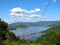
After crossing the bridge, SR 156 enters New Hope, which it traverses from west-to-east, providing its main traffic artery. Shortly after crossing the bridge, it intersects SR 422, which goes south to Long Island, AL. At this city's eastern limits, SR 156 intersects SR 377, which continues southward into Alabama (where it becomes Alabama State Route 73). Beyond this intersection, SR 156 crosses a mile-long causeway across Nickajack Lake, with the Nickajack Cove inlet to the south, and the main body of the lake to the north. The road runs parallel to a stretch of CSX railroad tracks along the length of the causeway.[1]
After reaching the main lakeshore, SR 156 turns northeastward, following the shore and the lower slopes of Sand Mountain before reaching an intersection with I-24 (Exit 161). Just past this intersection, the highway again crosses a section of the lake before terminating at its intersection with SR 134. From this point, SR 134 continues northward into Haletown and eastward toward Whiteside and northwestern Georgia.[1]
Junction list
| County | Location | mi | km | Destinations | Notes | |||
|---|---|---|---|---|---|---|---|---|
| Franklin | Sewanee | Northern terminus of SR 156 | ||||||
| Marion |
No major junctions | |||||||
| Franklin |
No major junctions | |||||||
| Marion | | Orme Mountain Road – Orme | End South-North designation | |||||
| South Pittsburg | Interchange | |||||||
| Interchange | ||||||||
| Tennessee River | Shelby Reinhart Bridge across Guntersville Lake | |||||||
| New Hope | Northern terminus of SR 422 | |||||||
| Northern terminus of SR 377 | ||||||||
| Haletown | I-24 exit 161 | |||||||
| Eastern terminus | ||||||||
| 1.000 mi = 1.609 km; 1.000 km = 0.621 mi | ||||||||
References
- 1 2 3 4 5 Tennessee Department of Transportation (2016). Official Transportation Map (PDF) (Map). c.1:1,013,760. Nashville: Tennessee Department of Transportation. §§ E9-E10. Retrieved September 28, 2016.
External links
