Tennessee State Route 111
| ||||
|---|---|---|---|---|
| Route information | ||||
| Maintained by TDOT | ||||
| Length | 118.72 mi (191.06 km) | |||
| Major junctions | ||||
| South end |
| |||
| North end |
| |||
| Location | ||||
| Counties | Hamilton, Sequatchie, Van Buren, White, Putnam, Overton, Pickett | |||
| Highway system | ||||
| ||||

State Route 111 (SR 111) is a north–south highway in Middle and East Tennessee. The road begins in Soddy-Daisy and ends north of Byrdstown in the community of Static, at the Tennessee/Kentucky state line. The length is 118.72 mi (191.1 km).[1]
Route description
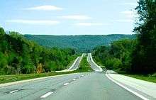
The highway begins at an interchange with U.S. Route 27/SR 29 (US 27/SR 29) in Soddy-Daisy. SR 111 travels generally northwest as a controlled access highway before it crosses into Sequatchie County. The controlled-access sections of SR 111 are unusual, as they contain 70 mph speed limits, which are generally reserved for Interstate highways. It then proceeds over Walden Ridge and into the Sequatchie Valley, where it comes to an interchange with US 127 and starts a concurrency with SR 8 in Dunlap, where the freeway ends. The concurrency goes up the Cumberland Plateau and into the northern part of the county where SR 8 splits off and continues to McMinnville. SR 111 turns north at this point and crosses into Van Buren County. Beyond this point, the majority of the road is a four-lane divided highway.
In Van Buren County, the highway travels through the small town of Spencer, passing just west of Fall Creek Falls State Park, and continues into White County at the Caney Fork River. In this area SR 111 runs a brief concurrency with SR 285. The highway then proceeds north as Harold "Mose" Sims Memorial Highway and joins the concurrency of US 70S/SR 1. The concurrency continues to the west side of Sparta, at which point the highways split up and SR 111 becomes controlled access again, continuing north into Putnam County.
Entering Putnam County by crossing the Falling Water River, the highway runs a brief concurrency with SR 136 before continuing north and passing through eastern Cookeville. Here it intersects Interstate 40 (I-40) and US 70N as it turns north-northeastward and into the town of Algood. After passing Algood, SR 111 turns northeastward and enters Overton County.
In Overton County, SR 111 becomes Cookeville Highway and then Veterans Memorial Parkway as it approaches Livingston. It becomes a bypass around the northwest of town, known as Bradford Hicks Drive, before exiting Livingston and continuing northeast as Byrdstown Highway. It crosses into Pickett County and becomes Livingston Highway. Then, it crosses the Obey River, impounded as Dale Hollow Lake, and enters Byrdstown.
After bypassing the center of Byrdstown, the highway continues northeastward as Robert H. Roberts Memorial Highway before ending at US 127/SR 28 in Static, just yards from the state line. From this intersection, US 127 runs northwestward to Albany, Kentucky, and southeastward toward Jamestown, Tennessee, while Kentucky Route 1076 continues northeastward to KY 696, which crosses Poplar Mountain in the direction of Monticello, Kentucky. If not for the mountain, this would be the straightest route along the western edge of the Cumberland Plateau from Byrdstown to Monticello. It has been suggested that TN 111 and parts of US 127, KY 90, US 27, KY 914, KY 80 and KY 461 be renumbered US 111 (a route that no longer exists) to create a clearly numbered route along the scenic western edge of the plateau, connecting Interstates 75, 40 and 24.[2]
History
SR 111 existed by 1938,[3] but only as a short portion of the current SR 111 route between the town of Spencer in Van Buren County and Doyle in White County and maintained this alignment at least through 1951.[4] By 1963, it had been extended south from Spencer to the Tennessee State Route 8 junction in Sequatchie County north of Cagle. Between 1975 and 1978, SR 111 was extended north to Cookeville replacing SR 42 in that section.[5] Between 1987 and 1989 the highway was extended northward over the remainder of the path of SR 42 to Static. Between 1990 and 1994, the section between SR 8 in Dunlap and US 27 between Soddy-Daisy and Bakewell was built. This extension was four lanes on the downgrades of Walden Ridge, and two lanes elsewhere, with the intent of eventually expanding the entirety to four lanes.[6] This was expanded to a four lane controlled-access highway between 2000 and 2004, which included replacing the four-way intersection with US 127 with an overpass and interchange.
Major intersections
| County | Location | mi | km | Destinations | Notes |
|---|---|---|---|---|---|
| Hamilton | Soddy-Daisy | 0.0 | 0.0 | Southern terminus; freeway continues as US 27 south (SR 29 south) | |
| 0.8 | 1.3 | Back Valley Road | |||
| | 4.4 | 7.1 | Jones Gap Road | ||
| Sequatchie | | 11 | 18 | Lewis Chapel Road | |
| | 14.7 | 23.7 | East Valley Road | ||
| Dunlap | 17.2 | 27.7 | Northern end of freeway; southern end of SR 8 concurrency; interchange | ||
| | 35.8 | 57.6 | |||
| | 29.9 | 48.1 | Northern end of SR 8 concurrency | ||
| Van Buren | | 36.5 | 58.7 | Interchange; western terminus of SR 284 | |
| Spencer | 44.8 | 72.1 | Interchange | ||
| | 49.6 | 79.8 | Southern end of SR 285 concurrency | ||
| White | | 51.4 | 82.7 | Northern end of SR 285 concurrency | |
| | 54.4 | 87.5 | Southern end of US 70S/SR 1 concurrency; interchange | ||
| Sparta | 57.5 | 92.5 | Interchange; northern end of SR 1 concurrency | ||
| 58.8 | 94.6 | Interchange; northern end of US 70S concurrency | |||
| 60.9 | 98.0 | Interchange | |||
| | 62.8 | 101.1 | Interchange | ||
| | 64.7 | 104.1 | O'Connor Road | Interchange | |
| | 67.2 | 108.1 | South end of SR 136 concurrency; interchange | ||
| Putnam | Cookeville | 70.5 | 113.5 | North end of SR 136 concurrency; interchange | |
| 73.3 | 118.0 | I-40 exit 288 | |||
| 74.5 | 119.9 | Interchange | |||
| 76.6 | 123.3 | Cookeville, Algood (10th Street) | Interchange | ||
| Overton | | 85.4 | 137.4 | Southern end of SR 293 concurrency | |
| | 85.5 | 137.6 | Northern end of SR 293 | ||
| Livingston | Interchange | ||||
| Southern end of SR 85 concurrency | |||||
| Northern end of SR 85 concurrency | |||||
| 94.7 | 152.4 | ||||
| 96.3 | 155.0 | Southern end of SR 294 concurrency | |||
| | 100 | 160 | Northern end of SR& 294 concurrency | ||
| Pickett | | 112 | 180 | Southern end of SR 325 concurrency | |
| | 113 | 182 | Northern end of SR 325 concurrency | ||
| Byrdstown | 115 | 185 | |||
| Static | 118.7 | 191.0 | Northern terminus; northern terminus of SR 28; road continues into Kentucky as US 127 north | ||
1.000 mi = 1.609 km; 1.000 km = 0.621 mi
| |||||
See also
| Wikimedia Commons has media related to Tennessee State Route 111. |


References
- ↑ Microsoft (2006). MapPoint (Map). Microsoft.
- ↑ http://www.mapquest.com/?le=t&saddr=&flv=1&vs=directions
- ↑ Tennessee Department of Highways and Public Works (1938). Road Condition Map of Tennessee Showing the designated Trunk Line System of State Highways (Map). Nashville: Tennessee Department of Highways and Public Works.
- ↑ Tennessee Department of Highways and Public Works (1951). Tennessee Highways (Map). Nashville: Tennessee Department of Highways and Public Works.
- ↑ Tennessee Department of Highways (1978). SR-111 Reconstruction, Appalachian Hwy Corridor J, White/Putnam Counties (Report). Federal Highway Administration. Retrieved 2018-01-16.
- ↑ Google (16 January 2018). "TN-111" (Map). Google Maps. Google. Retrieved 16 January 2018. February 25, 1999