Temperance Island
 | |
 Temperance Island  Temperance Island | |
| Geography | |
|---|---|
| Coordinates | 45°45′47″N 85°02′01″W / 45.7630644°N 85.0336748°WCoordinates: 45°45′47″N 85°02′01″W / 45.7630644°N 85.0336748°W |
| Adjacent bodies of water | Lake Michigan |
| Highest elevation | 584 ft (178 m) |
| Administration | |
| State | Michigan |
| County | Emmet County |
| Township | Bliss Township |
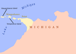
Temperance Island is an island off of Waugoshance Point, in Lake Michigan.[1] It is located in Bliss Township of Emmet County, Michigan. Temperance and nearby Waugoshance Island are part of the Wilderness State Park.[2] The Big Cut Canal separates the islands from Waugoshance Point. Together the islands form the northern boundary for sturgeon bay.[3]
Surrounding the island are shallow water shoals, that prove to be challenging for navigation. The White Shoal Light and the Grays Reef Light are also in the waters near the island.
References
- ↑ "Report For Temperance Island". USGNIS. Retrieved 18 April 2018.
- ↑ "Wilderness State Park". Pure Michigan. Retrieved 18 April 2018.
- ↑ "Plat book of Emmet County, Michigan". Michigan County Histories and Atlases. University of Michigan Digital Libraries. Retrieved 18 April 2018.
Lake Michigan Islands | ||
|---|---|---|
| Michigan |
|  |
| Wisconsin | ||
| Illinois | ||
This article is issued from
Wikipedia.
The text is licensed under Creative Commons - Attribution - Sharealike.
Additional terms may apply for the media files.