Te Akau
| Te Akau | |
|---|---|
| Hamlet | |
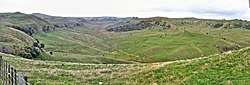 Raglan Limestone crags from Te Akau Coast Rd - typical of Te Akau scenery | |
 Te Akau | |
| Coordinates: 37°40′41″S 174°51′09″E / 37.67806°S 174.85250°ECoordinates: 37°40′41″S 174°51′09″E / 37.67806°S 174.85250°E | |
| Country | New Zealand |
| Region | Waikato Region |
| District | Waikato District |
| Elevation | 40 m (130 ft) |
| Population (2013 census) | |
| • Territorial | 57 |
| Time zone | UTC+12 (NZST) |
| • Summer (DST) | UTC+13 (NZDT) |
Te Akau is a very small, mainly farming, settlement in the North Island of New Zealand, located 62 km (39 mi) north west of Hamilton, 39 km (24 mi) south west of Huntly, 45 km (28 mi) south of Port Waikato and 47 km (29 mi), or 19 km (12 mi) by ferry and road, north of Raglan. It has a hall and a school.
Te Akau is also the name of a beach in Marlborough.[1]
Neighbouring areas | |
|---|---|
Boundaries
Te Akau's only defined boundaries are as a census 'area unit' and a former station. Te Akau hamlet is near the centre of both, but has no defined boundary. This article covers the census area unit, except Waingaro, Tawatahi River and Lakes Waitamoumou and Whangape.
Historically the name was applied to a sheep and cattle station extending from Port Waikato to Raglan, as shown on maps of 1905 (south)[2] and 1906 (north).[3]
Politically it is part of the Onewhero-Te Akau ward of Waikato District Council[4] (Onewhero is the area unit to the north, extending to the Waikato River and including Limestone Downs, Naike, Port Waikato and Pukekawa) and most of the area unit has been in the Taranaki-King Country general parliamentary constituency since 2014, though the northern area remains in Hunua. The Māori electorate is Hauraki-Waikato.[5]
Demographics
Te Akau area unit covers an area north of Whaingaroa Harbour, stretching north-east to Lake Whangape and north-west to the coast, covering several equally small settlements, including Kauri Flat, Ruakiwi, Waingaro, Dunmore, Pepepepe, Matira and Tikotiko.[6] It has the census figures in this table.[7] The relative increase in average income may reflect a growth in commuting (mainly to Hamilton and Huntly) from 51 in 2006, to 72 in 2013.[8]
In 2013 21.9% of the population was Māori.[9]
| Year |
Population |
Households |
Average income |
National average |
|---|---|---|---|---|
|
2001 |
900 | 318 | $18,200 | $18,500 |
|
2006 |
957 | 348 | $25,400 | $24,100 |
|
2013 |
930 | 348 | $31,800 | $27,900 |
Within that unit, Te Akau school and hall are on the northern edge of meshblock 0849400, which had these census figures [10]
| Year |
Population |
Households | Average income |
|---|---|---|---|
|
2001 |
60 | 18 |
$20,800 |
|
2006 |
42 | 18 |
$27,500 |
|
2013 |
57 | 21 | $28,800 |
Geology
The main geological groups represented in the area are the Kaihu Group of Holocene and Pleistocene pumiceous sands, silts, lignite, and dune sands, the Waitemata Group of Early Miocene sandstones, siltstones and limestones and Te Kuiti Group of Oligocene siltstones and limestones.[11] There are also a couple of small intrusions of Okete Volcanics on the fault to the north of Whaingaroa Harbour, at Te Kaha Point and Horea.[12]
Te Akau hamlet is mostly on Te Kuiti Group rocks of Waimai Limestone, with Carter Siltstone and Raglan Limestone on the higher ground.[11]
Ironsand
Following the successful smelting of 100 tons of ironsand in 1866,[13] in 1873 the station leaseholder asked the Government for a lease of the whole foreshore, including permission to use the ironsand, but was refused.[14] The major iron ore mineral is titanomagnetite.[15]

In 1957 New Zealand Steel Investigating Co started investigating creation of a steel industry in New Zealand, using N Island W coast ironsands. Its 1962 report led to Glenbrook steelworks and ironsand working at Taharoa and at Waikato North Head.[15] However, in the Raglan North Head area it is estimated there are 25.5 million tons of iron ore concentrate and in the Waikorea/Waimai area 20 million tons.[16]
Caves
The 1946 one-inch map showed many tomos and the cave[17] in Elgood Limestone,[11] which is now used by Adventure Waikato.[18]
Hot spring
Waikorea Hot Spring is about 54 °C (129 °F), with some 150 mg/kg Na, 185 mg/kg Cl, 9 mg/kg SO4, 33 mg/kg HCO3, 63 mg/kg SiO2 and a flow of about 0.5 imp gal/min (2.3 l/min). It has been suggested that Waikorea, Naike and Waingaro may all source their water from depths of more than 3,000 m (9,800 ft), as they all have similar chemical composition.[19]
Wildlife
A 1909 map showed a mixed podocarp-hardwood forest made up of kahikatea, rimu, rata and tawa. One of the requirements listed on the map was to 'improve' the land.[20] As early as 1912 there was a petition to protect 50 acres (20 ha) of puriri bush.[21] Bill Richards moved to Ruakiwi in 1912 and described, "The kaka, or bush parrot, was killed and eaten in large numbers. If by chance one was wounded it would hang by its beak on a limb and call out. In a matter of minutes thousands would answer its call. It was often possible to fill a sack (or run out of ammunition, whichever happened first) without shifting from that one tree." He also described how the bush was cleared and how soon kiwi and kaka became rare.[22]
The Department of Conservation has listed 66 plant species as characteristic of coastal Te Akau.[23] A 2007 study for the proposed windfarm listed 102 native plants and noted the main bush remnants as 285 ha (700 acres) at Te Kotuku Stream and 147 ha (360 acres) at Matira Road. 291 ha (720 acres) Waikorea Stream wetland has banded dotterel, paradise shelduck, pied stilt, spotless crake and seagulls.[24] Natural areas in Te Akau, apart from Lake Waikare, have no legal protection.[25]
History
The area has been inhabited since the 15C, but was greatly disrupted by war and colonisation in the 19C. In the 20C roads and other utilities were developed.
The archaeology map shows that most pre-colonial settlement was along the coast, especially around Whaingaroa harbour,[26] with over 250 recorded archaeological sites along the coast between Port Waikato and the harbour[27] and 151 in the proposed windfarm area.[28] Carbon from a camp fire at Waikorea was dated to between 1400 and 1440. Fragments of stone tools have been found; most of the obsidian recorded came from Tuhua Island, chert from Te Mata and adzes of metasomatised argillite from Marlborough.[27] Obsidian also came from Taupo and Coromandel and its distribution suggests transport over land, more than by river.[29]
In Māori tradition the Tainui waka sailed down the west coast from Manukau, where Poututeka, son of the leader of Tainui Hoturoa, was left behind, along with his son Hapopo.[30] Their descendants, Ngati Pou, were defeated at Whakatiwai on the Firth of Thames[31] and then settled in the Whangape[32] - Te Akau area.[30]
The name 'Te Akau' translates as 'beach' (of which there are several on this coast), but doesn't seem to have been used to describe this area until a report in 1862.[33] Prior to that, only Rangikahu, in the Waimai valley, a little to the north of Te Akau, was shown on maps and no mention was made of Te Akau when the Bishop of New Zealand walked down the coast in 1855.[34] By the time of an 1883 trip through Te Akau, Rangikahu was only a block of the station.[35]
Later history was investigated by a Te Akau Commission in 1904. It reported that Ngāti Tāhinga were the original owners of Te Akau Block, but Ngāti Koata acquired a right to a portion, until Waikato defeated Ngāti Koata. In 1817 Ngāti Koata were again attacked and about half fled to conquer both sides of Cook Strait. The other half (since called Tainui) went to Matakitaki, until Hongi Hika's 1822 musket war. Ngāti Māhanga then occupied Horea, though allowing some Tainui to live there, possibly because otherwise Waikato would have taken the land, or possibly as vassals. In 1849 C. W. Ligar, the Surveyor-General, paid £50 to Ngāti Mahuta.[36] A 2011 Waitangi Tribunal report reached much the same conclusion as in 1904, saying, "The resulting payment to Te Wherowhero and Ngati Mahuta does not seem have subsequently been regarded by the Crown as a valid sale."[37]
Te Akau was confiscated in 1863. In 1866 a map, showing about 158,600 acres (extending inland to Whangape Lake) claimed by Ngatitahinga and Tainui, was produced in Court. The Court decided there were 77 'loyal' and 44 'rebel' owners[36] (possibly the source of an 1870 return showing 133 of Ngatitahinga and Tainui living in the area between Port Waikato and Raglan. It also showed 108 of Tainui, Te Paitoka, Ngatitekore and Ngatikoata living at Horea).[38] Thus 94,668 acres were returned and 63,932 acres were kept by the Crown. A later survey reduced the area to 90,360 acres. On 23 October 1874, a grant was made to 88 of Ngatitahinga, Tainui and Ngati Mahuta.[36] On a raid to Taranaki prisoners had been brought back as Taurekarekas or slaves. Even when freed, many remained. After confiscation chiefs entered them on the 'loyal' list to increase the area of land returned. Some were displeased when they claimed their share.[39]
In 1894 Te Akau was divided into 3 pieces.[36] In 1903 an Assessment Court valued the Te Akau estate at £100,967.[40] The 1904 evidence is still disputed.[41] The report on the windfarm said Ngaati Tahinga have extensive interests from Port Waikato to the Tauterei Stream and Tainui Awhiro south from there, but also claiming interests north of the stream, as "hapu traditionally did not have immutable boundaries, but that their interests were at places permeable and overlapped with neighbours, particularly where they're closely related".[28] The Waitangi Tribunal is yet to report.
Mission station

Christianity spread to this area after 1828, due to missionary work in the north, and release of slaves taken north after the Musket Wars, some of whom returned to their former homes.[42] James and Mary Wallis started a mission station at Te Horea in 1835, but left it in 1836, due to a dispute with the Anglican Church.[43]
Cattle and sheep station
In 1868, after the disruption of the invasion of the Waikato and confiscation, H. C. Young leased the block from Whaingaroa Harbour to Waikato Heads for 27 years from Ngati-Tahinga and Tainui, at £800 a year.[36]
In 1874 a fresh 30 year lease to Canterbury businessmen and politicians, John Studholme and Thomas Russell, saw more bush cleared for grass and new farm buildings at the southern extremity of the station, just above the 1835 mission station site at Te Horea.[14] Merino sheep were brought from Canterbury and 135 bags of grass seed sown.[44] Ownership was transferred to New Zealand Land Association in 1892.[45]
Clearing 4,000 acres (1,600 ha) of bush from 1895 allowed 10,000 crossbred ewes to be run for breeding in 1898, in addition to the other 8,000 sheep and 5000 cattle. 500 to 600 fat cattle were sent to Auckland every year, swimming the Waikato and being driven to Auckland. Wool was shipped from the station jetty to Auckland. Sub-stations were opened at Waikato Heads, Ohuka and Mangati.[46] Most of the valleys were good quality land covered with virgin growth and native grasses.[47] In 1898 there were over 17,000 sheep on the station.[47]

Flax mills
Sam and Tom Wilson moved to Kerikeri in 1870 had a water-powered flax mill[48] in 1872, when Mrs Wilson was accused of kidnapping slaves.[49] A steam-powered flax mill at Te Aoterei was built in 1889.[50] The mill paid a royalty on the flax, and shipped dressed flax via the station's goods shed to Onehunga.[46] A tramway was built for it in 1906[51] and shown on the 1909 map.[20]
Subdivision
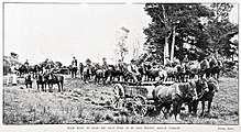
The Liberal government passed a Land for Settlements Act in 1894, to promote the break up of large stations.[52] Wars, confiscation and legislation had broken Māori links with the area, an 1883 visitor noting abandoned settlements,[35] so the remaining owners were willing to sell. After the lease ended in 1905,[53] the government started buying the land in 1907.[54] 1076 applications from 455 people for 14,178 acres (5,738 ha),[55] centred around Mangati[20] (a location on the 1909 plan,[20] but now only a road name), went into the ballot (see Auckland Weekly News photo) to purchase in 1909,[56] when government bought another 15,000 acres (6,100 ha).[57] Successful applicants came from all over North Island.[58]
Harbour Landings
When Te Akau was subdivided, water transport was still important, so wharves, and roads to them, were built on Whaingaroa Harbour at Ruakiwi (1914),[59] Mangiti and Te Akau Wharf, though that is 12 km (7.5 mi) from Te Akau. Te Akau Wharf was completed in 1918 with a shed,[60] allowing for vessels of up to a 12 1⁄2 ft (3.8 m) draught.[61] Presumably they declined as the roads took over the main transport role, though a ferry service still existed in 1938.[62]
Roads
Road construction started before subdivision, but there was an unexplained delay in 1909 and complaints of the lack of roads were being made in 1910.[63] Work was continuing on several roads in 1914.[64] Waikaretu Rd was finished in 1915.[65]
There are several roads in Te Akau area unit, including the road through Waingaro on former State Highway 22. The road to Te Akau Wharf was metalled in the 1930s.[66] The road from Ngaruawahia to Te Akau was completely sealed by 1976.[14]
Buses
In 1921 Bob Gibb of Ngaruawahia took over the mail run to Waingaro and Te Akau and cream run to the Ngaruawahia butter factory, with a solid tyred International.[67] In 1938 Western Highways started a service from Kawhia to Auckland via Makomako, Te Mata, Waingaro and Tuakau (via Highway 22) and back the next day. In 1946 Brosnan Motors started a daily run, leaving Kawhia at 5.45am, arriving at Auckland at 1pm, returning at 2 pm. and back at Kawhia about 9.30pm. In 1950 Brosnan Motors sold the Raglan-Kawhia run to Norman Rankin, who ended it in 1952. Brosnan Motors sold the Raglan-Auckland run to Pavlovich Motors in 1971. The first bus used on the Auckland-Kawhia run was a 7-seater Studebaker. Then a 10-seater Dodge used by Norman Collett later gave way to a 14-seater Oldsmobile. As the roads improved 18 and 21-seater Diamond T buses took over. Later 40-seaters ran from Raglan to Auckland,[68] until Pavlovich closed the route in 1976.[39]
Education
Te Akau School opened in 1913, Ruakiwi School in 1917 and Rukuruku School in 1923.[69] Two school buses[70] have replaced the other schools, leaving only Te Akau, a 2-classroom,[71] state full primary (years 1-8) school, with a roll of 37 in 2017.[72]
Memorial Hall
Te Akau-Waingaroa Community Centre opened beside the school on 29 March 1980,[73] after council set a special rate area to raise $41,000 in 1976.[14] It has playing fields, tennis courts, a nine-hole golf course, polo grounds[73] and a 210 m2 (2,300 sq ft) timber hall.[74] In 1995 a war memorial plaque was added.[73]
Utilities
A private telephone line was erected in 1918[22] to link with a cable laid under the harbour from Raglan.[75]
Electricity supply to 57 properties[76] was supported by a ballot in 1940[77] and connected a year later.[67]
A water bore just south of Te Akau has supplied 24 houses through 9 km (5.6 mi) of pipes since 1994.[78]
Windfarm
Hauāuru mā Raki Wind Farm was granted consent to build up to 168 wind turbines in 2011, but the project was dropped in 2013.[79]
See also
References
- ↑ "Te Akau (Black Beach), Marlborough". NZ Topo Map. Retrieved 2018-01-29.
- ↑ "Index map of Raglan county". www.aucklandcity.govt.nz. Retrieved 2018-01-27.
- ↑ "A cadastral map of Raglan county in Waikato". www.aucklandcity.govt.nz. Retrieved 2018-01-26.
- ↑ "Mayor and councillors". www.waikatodistrict.govt.nz. Retrieved 2018-01-22.
- ↑ "Interactive mapping of 2014 boundary changes". Electoral Commission. Retrieved 2018-01-24.
- ↑ "Geographic Boundary Viewer". archive.stats.govt.nz. Retrieved 2018-01-25.
- ↑ "2013 Census map – QuickStats about a place". www.stats.govt.nz. Retrieved 2016-02-07.
- ↑ "SNZ Commuter View". archive.stats.govt.nz. Retrieved 2018-01-27.
- ↑ "2013 Census QuickStats about a place". Retrieved 2018-01-29.
- ↑ "2013 Census map – QuickStats about a place". www.stats.govt.nz. Retrieved 2015-10-27.
- 1 2 3 "Te Akau: geological map". University of Waikato Library. 1966. Retrieved 2018-01-27.
- ↑ Clayton Waterhouse, Barry; P. J. White (1994). Geology of the Raglan-Kawhia Area. Institute of Geological & Nuclear Sciences (N.Z.). ISBN 0-478-08837-X.
- ↑ John Ingram, et. al. (May 1974). "Symposium on Taharoa ironsands project" (PDF). New Zealand Engineering.
- 1 2 3 4 CW Vennell & Susan Williams (1976). Raglan County Hills and Sea 1876-1976. Wilson & Horton for Raglan County Council. ISBN 0868640026.
- 1 2 Kear, David (1979). Geology of Ironsand Resources of New Zealand (with Notes on Limestone, Silica and Bentonite): Report. Science Information Division.
- ↑ Tony Christie and Bob Brathwaite. "Mineral Commodity Report 15 — Iron" (PDF). MBIE.
- ↑ "Provisional edition Te Akau Sheet N55". www.mapspast.org.nz. Retrieved 2018-01-25.
- ↑ "Caving". adventurewaikato.co.nz. Retrieved 2018-01-25.
- ↑ M.P. HOCHSTEIN, S. SISWOJO, A.S. KASONTA, (1985). "NAIKE HOT SPRINGS: A HOT SPRING SYSTEM" (PDF). Geothermal Institute University of Auckland.
- 1 2 3 4 "Plan of locality Te Akau Block (Part of) Block XII". www.aucklandcity.govt.nz. 1909. Retrieved 2018-01-24.
- ↑ "Roads to Te Akau Block". New Zealand Herald. 1912-08-19. p. 8. Retrieved 2018-01-28.
- 1 2 Richards, Bill. Off the Sheep's Back.
- ↑ "Planting guide for Western Waikato" (PDF). Department of Conservation.
- ↑ Britta Deichmann, Gerry Kessels (May 2007). "WAIKATO WIND FARM - CONTACT WIND LTD – ECOLOGICAL SCOPING ASSESSMENT".
- ↑ R Ryer, J Bentley, L Saunders and Dr S De Luca (2016). "Natural Character Study of the Waikato Coastal Environment" (PDF). Waikato Regional Council.
- ↑ "NZAA Site Viewer". archsite.eaglegis.co.nz. Retrieved 2018-06-14.
- 1 2 John Ogden, Neville A. Ritchie, Phillip R. Moore (September 2008). "An Early Artefact Assemblage from the Northern Waikato Coast" (PDF). New Zealand Archaeological Association.
- 1 2 "Final Report and Decision of the Board of Inquiry into the Hauāuru mā Raki Wind Farm and Infrastructure Connection to Grid" (PDF). Ministry for the Environment. May 2011.
- ↑ Moore, Phillip R. (2011). "Journal of Pacific Archaeology – Cultural Distribution of Obsidian along the Waikato-King Country Coastline".
- 1 2 Kahotea, Des Tatana (July 2013). "Rangitahi Peninsula Archaeological and Cultural Survey and Assessment - Report for Raglan Land Company" (PDF).
- ↑ Ballara, Angela (1998). Iwi: The Dynamics of Māori Tribal Organisation from C.1769 to C.1945. Victoria University Press. ISBN 9780864733283.
- ↑ "Journal of the Polynesian Society: Pare Hauraki - Pare Waikato, By George Graham, P 68-76". www.jps.auckland.ac.nz. 1949. Retrieved 2018-01-27.
- ↑ "Parliamentary Papers | Appendix to the Journals of the House of Representatives | 1862 Session - FURTHER PAPERS RELATIVE TO GOVERNOR SIR GEORGE GREY'S PLAN OF NATIVE GOVERNMENT. REPORT OF OFFICERS". paperspast.natlib.govt.nz. Retrieved 2018-01-27.
- ↑ "Journal of a Walk with the Bishop of New Zealand, from Auckland to Taranaki, by C. J. Abraham (1856)". anglicanhistory.org. Retrieved 2018-01-27.
- 1 2 "Rough Notes of a Trip Through Te Akau Station. (by Our Raglan Correspondent". Waikato Times. 1883. p. 3. Retrieved 2018-01-27.
- 1 2 3 4 5 "G-01 Te Akau Block (report of the Royal Commission On)".
- ↑ Boulton (August 2011). "Hapu and Iwi Land Transactions with the Crown and Europeans in Te Rohe Potae Inquiry District, c. 1840 –1865" (PDF).
- ↑ "Appendix to the Journals of the House of Representatives | 1870 Session I RETURN GIVING THE NAMES, ETC., OF THE TRIBES OF THE NORTH ISLAND". paperspast.natlib.govt.nz. Retrieved 2018-02-06.
- 1 2 R T Vernon: Raglan
- ↑ "RAGLAN NOTES. (Waikato Argus, 1903-07-25)". paperspast.natlib.govt.nz. Retrieved 2018-01-23.
- ↑ "Submission to the committee regarding the Marine and Coastal Area (Takutai Moana) Bill 2010".
- ↑ "Missions and missionaries". teara.govt.nz. Retrieved 2018-01-25.
- ↑ Luxton, C. T. J. (March 1965). "The Rev. James Wallis" (PDF).
- ↑ "New Zealand Herald". 1877-04-27. p. 2. Retrieved 2018-01-28.
- ↑ "Raglan County Council". Waikato Times. 1892-02-27. p. 2. Retrieved 2018-01-28.
- 1 2 "THROUGH WAIKATO. (New Zealand Herald, 1893-05-27)". paperspast.natlib.govt.nz. Retrieved 2018-01-23.
- 1 2 "AtoJs Online — Appendix to the Journals of the House of Representatives — 1898 Session I — H-23 THE ANNUAL SHEEP RETURNS FOR THE YEAR ENDED 30th APRIL, 1898". atojs.natlib.govt.nz. Retrieved 2018-01-24.
- ↑ Vernon, R T (1975). Te Uku.
- ↑ "Kidnapping in Auckland". Auckland Star. 1872-06-10. p. 2. Retrieved 2018-01-25.
- ↑ "RAGLAN. (Waikato Times, 1889-10-26)". paperspast.natlib.govt.nz. Retrieved 2018-01-23.
- ↑ "RAGLAN. (Waikato Times, 1906-08-20)". paperspast.natlib.govt.nz. Retrieved 2018-01-23.
- ↑ Taonga, New Zealand Ministry for Culture and Heritage Te Manatu. "5. – Land ownership – Te Ara Encyclopedia of New Zealand". teara.govt.nz. Retrieved 2018-01-27.
- ↑ "RAGLAN. (Waikato Argus, 1905-07-18)". paperspast.natlib.govt.nz. Retrieved 2018-01-23.
- ↑ "RAGLAN NEWS. (Auckland Star, 1907-05-04)". paperspast.natlib.govt.nz. Retrieved 2018-01-23.
- ↑ "Te Akau Block. (Waikato Argus, 1909-09-30)". paperspast.natlib.govt.nz. Retrieved 2018-01-23.
- ↑ "Te Akau Block Opened. (Waikato Argus, 1909-09-02)". paperspast.natlib.govt.nz. Retrieved 2018-01-23.
- ↑ "Te Akau Block. (Waikato Argus, 1909-09-30)". paperspast.natlib.govt.nz. Retrieved 2018-01-23.
- ↑ "TE AKAU BLOCK. (Bay of Plenty Times, 1909-10-15)". paperspast.natlib.govt.nz. Retrieved 2018-01-23.
- ↑ "Raglan County Council". Waikato Argus. 1914-03-12. p. 2. Retrieved 2018-01-28.
- ↑ "Raglan County Council". Waikato Times. 1918-09-12. p. 2. Retrieved 2018-01-24.
- ↑ "Local and General". Waikato Times. 1919-02-03. p. 4. Retrieved 2018-01-24.
- ↑ "Raglan Affairs". New Zealand Herald. 1938. p. 17. Retrieved 2018-01-24.
- ↑ "TE AKAU GRIEVANCES. (New Zealand Herald, 1910-08-26)". paperspast.natlib.govt.nz. Retrieved 2018-01-23.
- ↑ "RAGLAN COUNTY COUNCIL. (Waikato Argus, 1914-03-12)". paperspast.natlib.govt.nz. Retrieved 2018-01-23.
- ↑ "RAGLAN COUNTY COUNCIL (Waikato Times, 1915-07-16)". paperspast.natlib.govt.nz. Retrieved 2018-01-23.
- ↑ "AtoJs Online — Appendix to the Journals of the House of Representatives — 1935 Session I — D-01 PUBLIC WORKS STATEMENT (BY THE HON. J. BITCHENER, MINISTER OF PUBLIC WORKS)". atojs.natlib.govt.nz. Retrieved 2018-01-23.
- 1 2 Seavill, Geoffrey. PACK HORSE TO JET the story of Waingaro from 1868.
- ↑ R T Vernon: Aotea Chapter 32
- ↑ "Reprinted from Raglan Chronicle, 11th August 2016 – Raglan & District Museum". raglanmuseum.co.nz. Retrieved 2018-01-25.
- ↑ "Te Akau School - Our School". www.sporty.co.nz. Retrieved 2018-01-23.
- ↑ "Te Akau School - 16/11/2017". Education Review Office. Retrieved 2018-01-23.
- ↑ "Schools / Homepage - Te Kete Ipurangi (TKI)". www.tki.org.nz. Retrieved 2018-01-23.
- 1 2 3 "Te Akau-Waingaroa memorial plaque". nzhistory.govt.nz. Retrieved 2018-01-22.
- ↑ "Community halls". www.waikatodistrict.govt.nz. Retrieved 2018-01-22.
- ↑ "Local and General News". Waikato Times. 1918. p. 4. Retrieved 2018-01-24.
- ↑ "Power Supply". New Zealand Herald. 1938-04-14. p. 15. Retrieved 2018-01-25.
- ↑ "£13,000 Loan Approved". New Zealand Herald. 1940-06-21. p. 6. Retrieved 2018-01-24.
- ↑ "Water Supply AMP Version" (PDF). Waikato District Council. December 2014.
- ↑ "NZ Wind Energy - Exit of Hauāuru mā raki Development". www.scoop.co.nz. Retrieved 2018-01-27.
External links
Photos -