Tanami Road
| Tanami Road Tanami Track / McGuire Track Northern Territory–Western Australia | |
|---|---|
 | |
| Map of the Northern Territory and northern Western Australia with Tanami Road highlighted in red | |
| General information | |
| Type | Road |
| Length | 1,035 km (643 mi) |
| Route number(s) |
|
| Major junctions | |
| South-east end |
|
| North-west end |
|
| Location(s) | |
| Region | Tanami desert |
| Restrictions | |
| Fuel supply | Tilmouth Well |
The Tanami Road, also known as the Tanami Track and the McGuire Track, runs between the Stuart Highway in the Northern Territory and the Great Northern Highway in Western Australia. Its southern junction is 19 km (12 mi) north of Alice Springs and the northern junction is 17 km (11 mi) south west of Halls Creek. It follows a cattle droving route northwest from the MacDonnell Ranges area of central Australia to Halls Creek in the Kimberley.[1]
The Tanami Road is the most direct route from Alice Springs to the Kimberley, passing through the Tanami Desert. Along its route are Yuendumu[2] and The Granites gold mine owned by Newmont Mining. In the Northern Territory it passes through land owned by the Aboriginal Warlpiri people, and in Western Australia it passes through pastoral land.
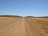
About 20% of the road is bitumen, the remainder is dirt and gravel and, although it is navigable by two-wheel drive vehicles, a four-wheel drive is recommended. Some parts of the road are prone to severe corrugations, making for an uncomfortable and slow drive at times.[3]
The mid-way point, Rabbit Flat, formerly a public roadhouse, was closed indefinitely at the end of 2010, so planning for this journey must take the lack of fuel and supplies into account.[4] Tilmouth Well, located 186 km (116 mi) from Alice Springs between Alice Springs and Rabbit Flat,[5] provides fuel service 7 days a week.[4] Carrying adequate fuel and water supplies is essential.
The astronomer Eugene Shoemaker, best known for his co-discovery of the comet Shoemaker–Levy 9, died in a car accident while travelling along the Tanami Road in 1997.

See also
![]()
References
- ↑ Hema, Maps (2006). Australia's Great Desert Tracks NC Sheet (Map). Eight Mile Plains Queensland: Hema Maps. ISBN 978-1-86500-163-0.
- ↑ Yuendumu Mining Company N.L (1980). In The Tanami road : the Aboriginal-owned Yuendumu Mining Company N.L. submission to Parliamentary Standing Committee on Public Works. Yuendumu Mining Company N.L, Darwin
- ↑ Cathy Van Extel (2013-05-28). "Is the Tanami Road the worst highway in Australia?". Australian Broadcasting Corporation. Retrieved 2013-05-30.
- 1 2 "The Tanami Desert, Australia". Outback Australia Travel Guide. Retrieved 2011-04-22.
- ↑ http://www.tilmouthwell.com/ Tilmouth Well
Further reading
- Deckert, John.(1993) Tanami Track map - Nhill, Vic : Westprint Heritage Maps, 1992. Scale 1:1,000,000 (E 127°20' -- E 134°00/S 17°25' -- S 24°00'). ISBN 1-875608-11-7
- Upgrading the Tanami Road - Economic Impact Study (PDF), Cummings Economics, October 2011
External links
Road infrastructure in Northern Territory | ||
|---|---|---|
| National highways | ||
| Highways | ||
| Major urban roads | ||
| Outback tracks and numbered state routes | ||
Road infrastructure in Western Australia | ||
|---|---|---|
| Freeways | ||
| Metropolitan highways | ||
| Highways and major roads |
| |
| Outback tracks | ||
| Lists |
| |