Tamakautoga
| Tamakautoga | |
|---|---|
| Village | |
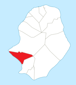 Tamakautoga council within Niue | |
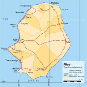 Administrative map of Niue showing all the villages | |
| Coordinates: 19°06′14″S 169°55′01″W / 19.10389°S 169.91694°WCoordinates: 19°06′14″S 169°55′01″W / 19.10389°S 169.91694°W | |
| Country |
|
| Tribal Area | Tafiti |
| Area | |
| • Total | 11.93 km2 (4.61 sq mi) |
| Population (2011) | |
| • Total | 157 |
| • Density | 13.16/km2 (34.1/sq mi) |
| Time zone | UTC-11 (UTC-11) |
| Area code(s) | +683 |
Tamakautoga is one of the fourteen villages of Niue.[1] Its population at the 2001 census was 140,[2] and 157 in 2011.
References
- ↑ 1558550 Tamakautoga on OpenStreetMap
- ↑ Statoids.com. Retrieved December 8, 2010
This article is issued from
Wikipedia.
The text is licensed under Creative Commons - Attribution - Sharealike.
Additional terms may apply for the media files.