Hakupu
| Hakupu | |
|---|---|
| Village | |
 Hakupu council within Niue | |
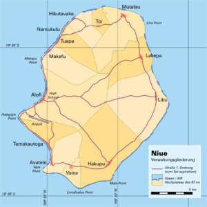 Administrative map of Niue showing all the villages | |
| Coordinates: 19°06′S 169°50′W / 19.100°S 169.833°WCoordinates: 19°06′S 169°50′W / 19.100°S 169.833°W | |
| Country |
|
| Tribal Area | Tafiti |
| Area | |
| • Total | 48.04 km2 (18.55 sq mi) |
| Population (2011) | |
| • Total | 129 |
| • Density | 2.69/km2 (7.0/sq mi) |
| Time zone | UTC-11 (UTC-11) |
| Area code(s) | +683 |
Hakupu is one of the fourteen villages of the island of Niue.[1] According to the 2006 census, it has a population of 162, making it the third-largest village in Niue.[2]
Geography
It is located in the southeast of the island, close to Matatamane Point, and is connected by road with the capital Alofi (12 kilometres to the northwest), Avatele (7 kilometres to the west), and via the east coast road to Liku (12 kilometres), Lakepa (16 kilometres), and Mutalau (on the north coast, 20 kilometres away).
References
- ↑ 1558543 Hakupu on OpenStreetMap
- ↑ "Niue Villages" Statoids. Retrieved 2014-05-09.
This article is issued from
Wikipedia.
The text is licensed under Creative Commons - Attribution - Sharealike.
Additional terms may apply for the media files.