Takhli District
| Thakli ตาคลี | |
|---|---|
| Amphoe | |
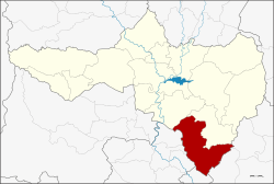 Amphoe location in Nakhon Sawan Province | |
| Coordinates: 15°15′47″N 100°20′37″E / 15.26306°N 100.34361°ECoordinates: 15°15′47″N 100°20′37″E / 15.26306°N 100.34361°E | |
| Country | Thailand |
| Province | Nakhon Sawan |
| Seat | Thakli |
| Area | |
| • Total | 854.1 km2 (329.8 sq mi) |
| Population (2005) | |
| • Total | 114,912 |
| • Density | 130/km2 (350/sq mi) |
| Time zone | UTC+7 (ICT) |
| Postal code | 60140 |
| Geocode | 6007 |
Thakhli (Thai: ตาคลี, pronounced [tāː.kʰlīː]) is the southernmost district (amphoe) of Nakhon Sawan Province, Thailand.
The name of the district originates from the Tikhli ground in Sang Thong, the royal novel of King Rama III.
Geography
Neighboring districts are (from the north clockwise) Phayuha Khiri and Tak Fa of Nakhon Sawan, Nong Muang and Ban Mi of Lopburi Province, In Buri of Singburi Province and Sapphaya, Mueang Chai Nat and Manorom of Chainat Province.
Administration
The district is divided into 11 sub-districts (tambon), which are further subdivided into 128 villages (muban). Takhli itself has town status (thesaban mueang) and covers part of the tambon Takhli. Chong Khae is a township (thesaban tambon) and covers parts of tambon Chong Khae and Phrom Nimit. There are a further 10 tambon administrative organizations (TAO).
| No. | Name | Thai name | Villages | Pop. |
|---|---|---|---|---|
| 1. | Takhli | ตาคลี | 24 | 53,322 |
| 2. | Chong Khae | ช่องแค | 12 | 9,160 |
| 3. | Chan Sen | จันเสน | 11 | 8,131 |
| 4. | Huai Hom | ห้วยหอม | 11 | 4,914 |
| 5. | Hua Wai | หัวหวาย | 14 | 9,399 |
| 6. | Nong Pho | หนองโพ | 15 | 10,519 |
| 7. | Nong Mo | หนองหม้อ | 7 | 3,862 |
| 8. | Soi Thong | สร้อยทอง | 10 | 4,618 |
| 9. | Lat Thippharot | ลาดทิพรส | 11 | 5,201 |
| 10. | Phromnimit | พรหมนิมิต | 9 | 5,786 |
External links