Tai'erzhuang District
| Tai'erzhuang District 台儿庄区 | |
|---|---|
| District | |
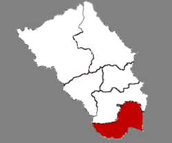 Location in Zaozhuang | |
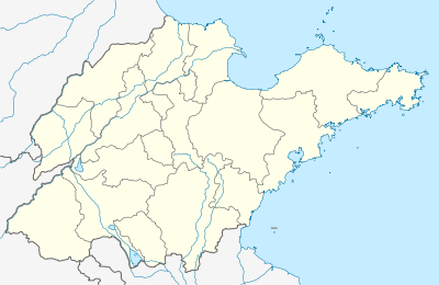 Tai'erzhuang Location in Shandong | |
| Coordinates: 34°33′38.84″N 117°44′17.69″E / 34.5607889°N 117.7382472°ECoordinates: 34°33′38.84″N 117°44′17.69″E / 34.5607889°N 117.7382472°E | |
| Country | People's Republic of China |
| Province | Shandong |
| Prefecture-level city | Zaozhuang |
| Time zone | UTC+8 (China Standard) |
| Website |
www |
| Tai'erzhuang | |||||||||||||
| Simplified Chinese | 台儿庄 | ||||||||||||
|---|---|---|---|---|---|---|---|---|---|---|---|---|---|
| Traditional Chinese | 台兒莊 | ||||||||||||
| Postal | Taierhchwang | ||||||||||||
| |||||||||||||
Tai'erzhuang District (Chinese: 台儿庄区; pinyin: Tái'érzhuāng Qū) is the southernmost of five districts under the administration of the prefecture-level city of Zaozhuang. The district is located in the south of Shandong Province, China, bordering Jiangsu province to the south. It covers an area of 538 km2 (208 sq mi) and has a population of 290,000.
The district was the site of the Battle of Taierzhuang fought between the armies of the Chinese Kuomintang and Japan in 1938 during the Second Sino-Japanese War. The former site of the battle (台儿庄大战旧址; Tái'érzhuāng dàzhàn jiùzhǐ) has been listed as a national monument of the People's Republic of China since 2006 (resolution number 6-981).
See also
External links
| Sub-provincial cities |
| ||||||||||||||||||||||||||||||
|---|---|---|---|---|---|---|---|---|---|---|---|---|---|---|---|---|---|---|---|---|---|---|---|---|---|---|---|---|---|---|---|
| Prefecture-level cities |
| ||||||||||||||||||||||||||||||
| |||||||||||||||||||||||||||||||
This article is issued from
Wikipedia.
The text is licensed under Creative Commons - Attribution - Sharealike.
Additional terms may apply for the media files.