Türkheim
| Türkheim | ||
|---|---|---|
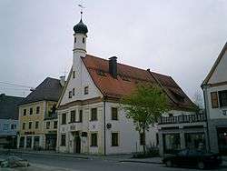 The old town hall | ||
| ||
 Türkheim Location of Türkheim within Unterallgäu district 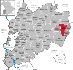 | ||
| Coordinates: 48°4′N 10°37′E / 48.067°N 10.617°ECoordinates: 48°4′N 10°37′E / 48.067°N 10.617°E | ||
| Country | Germany | |
| State | Bavaria | |
| Admin. region | Schwaben | |
| District | Unterallgäu | |
| Municipal assoc. | Türkheim | |
| Government | ||
| • Mayor | Sebastian Seemüller (CSU) | |
| Area | ||
| • Total | 23.52 km2 (9.08 sq mi) | |
| Elevation | 598 m (1,962 ft) | |
| Population (2017-12-31)[1] | ||
| • Total | 7,208 | |
| • Density | 310/km2 (790/sq mi) | |
| Time zone | CET/CEST (UTC+1/+2) | |
| Postal codes | 86842 | |
| Dialling codes | 08245 | |
| Vehicle registration | MN | |
| Website | www.tuerkheim.de | |

Türkheim is a municipality in the district of Unterallgäu in Bavaria, Germany. The neighboring places of Türkheim are Ettringen, Berg, Rammingen, Irsingen, Wiedergeltingen and Amberg. The administrative collectivity of Türkheim administrate Türkheim and Irsingen. The town is seat of a municipal association with Amberg, Rammingen and Wiedergeltingen.
References
| Wikimedia Commons has media related to Türkheim. |
| Authority control |
|---|
This article is issued from
Wikipedia.
The text is licensed under Creative Commons - Attribution - Sharealike.
Additional terms may apply for the media files.