Ottobeuren
| Ottobeuren | ||
|---|---|---|
 Basilica and market square in Ottobeuren | ||
| ||
 Ottobeuren Location of Ottobeuren within Unterallgäu district 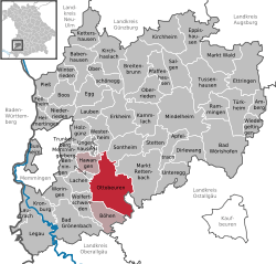 | ||
| Coordinates: 47°56′29″N 10°17′58″E / 47.94139°N 10.29944°ECoordinates: 47°56′29″N 10°17′58″E / 47.94139°N 10.29944°E | ||
| Country | Germany | |
| State | Bavaria | |
| Admin. region | Schwaben | |
| District | Unterallgäu | |
| Municipal assoc. | Ottobeuren | |
| Government | ||
| • Mayor | Bernd Schäfer | |
| Area | ||
| • Total | 55.85 km2 (21.56 sq mi) | |
| Elevation | 669 m (2,195 ft) | |
| Population (2017-12-31)[1] | ||
| • Total | 8,314 | |
| • Density | 150/km2 (390/sq mi) | |
| Time zone | CET/CEST (UTC+1/+2) | |
| Postal codes | 87724 | |
| Dialling codes | 08332 | |
| Vehicle registration | MN | |
| Website | www.ottobeuren.de | |

Ottobeuren, traditionally known as Ottembura in English (Swabian: Ottobeire), is a municipality in Bavaria, Germany, located 11 km southeast of Memmingen near the A7. It is famous for Ottobeuren Abbey, situated next to the Basilica. The town is seat of a municipal association with Hawangen and Böhen.
Twin towns — sister cities
Ottobeuren is twinned with:


References
- ↑ "Fortschreibung des Bevölkerungsstandes". Bayerisches Landesamt für Statistik und Datenverarbeitung (in German). September 2018.
| Authority control |
|---|
This article is issued from
Wikipedia.
The text is licensed under Creative Commons - Attribution - Sharealike.
Additional terms may apply for the media files.