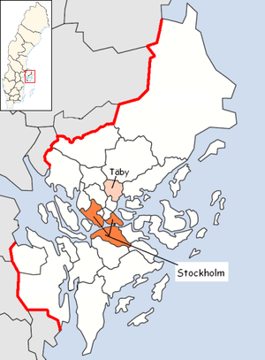
Täby Municipality
| Täby Municipality Täby kommun | ||
|---|---|---|
| Municipality | ||
 | ||
| ||
 | ||
| Country | Sweden | |
| County | Stockholm County | |
| Seat | Täby | |
| Area[1] | ||
| • Total | 71.22 km2 (27.50 sq mi) | |
| • Land | 60.72 km2 (23.44 sq mi) | |
| • Water | 10.5 km2 (4.1 sq mi) | |
| Area as of 1 January 2014. | ||
| Population (31 December 2017)[2] | ||
| • Total | 70,405 | |
| • Density | 990/km2 (2,600/sq mi) | |
| Time zone | UTC+1 (CET) | |
| • Summer (DST) | UTC+2 (CEST) | |
| ISO 3166 code | SE | |
| Province | Uppland | |
| Municipal code | 0160 | |
| Website | www.taby.se | |
| Density is calculated using land area only. | ||

Täby Municipality (Täby kommun) is a municipality north of Stockholm in Stockholm County in east central Sweden. Its seat is located in the town of Täby. Täby Municipality can be characterized as a suburb of Stockholm.
The municipality is one of few in Sweden which has approximately the same size as the original entity created out of Täby parish, when the first local government acts came into force in 1863. It has not been amalgamated with other units, but minor changes of its limits have been carried out.
Localities
For statistical purposes the municipality is divided into two non-administrative urban areas (tätort). The southern built-up area constituted until 2014 the multimunicipal [3] urban area Täby which was partly situated in Danderyd Municipality. From 2015 it is considered part of Stockholm urban area
The northern built-up area, (Täby kyrkby) is part of the bimunicipal [3] Vallentuna urban area, of which the main part constitutes the seat of Vallentuna Municipality.
Public transportation
The municipality is served by the Stockholm public transport system through SL. There are twelve stops on all the three branches of the narrow gauge Roslagsbanan suburban railway. There is also bus connection with the Stockholm metro as well as an extensive internal bus network.
History
During the first millennium, Täby was part of the lands of the Svear, known as Svitjod. Remains from this period can be found in more than 37 runestones found in the municipality.[4] In the north of the municipality, the remains of the 11th-century bridge known as Jarlabankes bridge, can be found. The cross on Täby's coat of arms is found on the Risbylestenen, a runestone, in the northern part of the municipality. It is said that this runestone shows the first signs of Christianity reaching this part of Europe. During the Middle Ages, Täby was part of the Attundaland region.
Täby remained a rural community until the 19th century. Most of the land was owned by the noble families. During the 16th and 17th centuries, most of the land in eastern Täby was owned by the Brahe family of Rydboholm Manor. Other noble families owning land in Täby at different times during this period were Banér, Bååth, Roos, Sparre, Gyllenstierna and Meijerfeldt. The latter two owned, at different times, Näsby Slott (manor) in the southeast of the municipality. By 1790 Täby had a population of approximately 900 people, most of them living on one of the 36 farms. By the end of the 19th century the population had grown to approximately 1,250.
In 1885 the Roslagsbanan narrow-gauge railway was built, connecting Täby with the city of Stockholm. Täby experienced a population expansion. People settled near the railway stations. In 1902 the wealthy engineer Carl Robert Lamm acquired the burned down Näsby Slott and rebuilt it. Around the time of the First World War many citydwellers in Stockholm acquired small summer residences in the eastern part of Täby, what is now Näsbypark. By 1919 Täby's population had grown to 3,000. Some years after Second World War Täby increasingly became a suburb of Stockholm, and by 1947 the population had increased to 8,584, concentrated in the southern and eastern parts of the municipality.
In 1948 Täby acquired the title of a "merchant town" (Swedish: köping), valid until the reform of 1971. This was also the beginning of the large scale development of Täby, led by the mayor Gustaf Berg. By 1975 the population had increased to 41,307 people.[5]
Today, Täby is considered an attractive suburb to Stockholm with one of the highest median incomes in Sweden.
Politics
Täby has for a long period of time been run by a coalition of centre-right parties. Filippa Reinfeldt, ex-wife of Fredrik Reinfeldt (the former Swedish Prime Minister and former leader of the Moderate Party), had been mayor of Täby for a long time, until Jan Rosenberg, of the Moderate Party,[6] became the current mayor of Täby Municipality.
The slogan of the municipality is today in translation "Täby, the city on the countryside".
Sights
- Runestones: There are 37 identified runestones in Täby. Their inscriptions have provided many interesting and useful insights into the life and destinies of the people of the Viking Age. Judging from the inscriptions of the runestones and legends, the most important man at that time was Jarlabanke. He has also given name to the remains of a Viking age bridge - Jarlabanke's bridge.
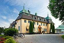
- Näsby Manor: Originally built in the 1660s and designed by Nicodemus Tessin the Elder, Näsby Manor is located in the picturesque and natural setting of Näsbyviken shore. The manor was burned to the ground in 1897, but was rebuilt according to the original design on the initiative of Carl Robert and Dora Lamm who moved into the manor in 1905. Parts of the old manor garden still exist and are being well preserved.
- Taby Racecourse: Sweden's largest horse racing track, inaugurated in 1960.
- Täby Church: Built in the 13th century. It houses a triptych from the 15th century. The most notable objects are the wall paintings from the medieval times, painted by Albertus Pictor. One of them, Death playing chess, portrays a man playing chess with the Grim Reaper and was the inspiration for the movie director Ingmar Bergman when he made the perhaps best known Swedish movie ever, The Seventh Seal.
- Täby Centrum: Sweden's largest shopping mall.[7]
Notable natives
- Sara Danius (b. 1962), professor of aesthetics, former permanent secretary of the Swedish Academy
- Henrik Holm (b. 1968), professional tennis player
- Sara Lumholdt (b. 1984), singer and former member of pop band A*Teens
- Kristian Luuk (b. 1966), comedian and talk show-host
- Eric Prydz (b. 1976), DJ and producer
- Fredrik Reinfeldt (b. 1965), politician, Prime Minister of Sweden 2006-2014
- Filippa Reinfeldt (b. 1967), politician, former Mayor and Commissioner of Täby, Commissioner of Health Services of Stockholm County 2006-2014, former wife of Fredrik Reinfeldt
- Johan Rheborg (b. 1963), comedian
Sister towns
Täby is twinned with the following municipalities:


Gallery
 Såstaholm manor, now used as a conference site
_2009_T%C3%A4by_(1).jpg) The Storstugan building close to Täby centrum
The Storstugan building close to Täby centrum_2009.jpg) Täby centrum shopping mall
Täby centrum shopping mall Municipal building of Täby Municipality.
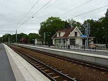 Viggbyholm station at Roslagsbanan.
 Road in Näsbypark with railroad crossing of Roslagsbanan.
References
- ↑ "Statistiska centralbyrån, Kommunarealer den 1 januari 2014" (Microsoft Excel) (in Swedish). Statistics Sweden. Retrieved 2014-04-18.
- ↑ "Folkmängd i riket, län och kommuner 31 december 2017" (in Swedish). Statistics Sweden. February 21, 2018. Retrieved February 21, 2018.
- 1 2 http://w41.scb.se/templates/Publikation____186288.asp%5Bpermanent+dead+link%5D
- ↑ "Archived copy". Archived from the original on 2006-06-30. Retrieved 2006-06-19.
- ↑ "Archived copy". Archived from the original on 2006-09-26. Retrieved 2006-06-19.
- ↑ "Archived copy". Archived from the original on 2007-12-17. Retrieved 2007-06-07.
- ↑ "Täby Centrum". www.tabycentrum.se.
- 1 2 3 4 5 "Vänorter" (in Swedish). Täby kommun. Archived from the original on 2011-04-03.
- ↑ "Välissuhted" (in Estonian). Viimsi vald. Retrieved 5 March 2011.
External links
- Official website
- Täby Galopp - Provides a page in English
- Täby Centrum
Municipalities and seats of Stockholm County | ||
|---|---|---|
| Municipalities | ||
| Municipal seats | ||