Danderyd Municipality
| Danderyd Municipality Danderyds kommun | ||
|---|---|---|
| Municipality | ||
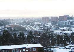 2006 wintertime view over Danderyd | ||
| ||
 | ||
| Country | Sweden | |
| County | Stockholm County | |
| Seat | Djursholm | |
| Area[1] | ||
| • Total | 32.67 km2 (12.61 sq mi) | |
| • Land | 26.4 km2 (10.2 sq mi) | |
| • Water | 6.27 km2 (2.42 sq mi) 18.6% | |
| Area as of 1 January 2014. | ||
| Population (31 December 2017)[2] | ||
| • Total | 32,888 | |
| • Density | 1,000/km2 (2,600/sq mi) | |
| Time zone | UTC+1 (CET) | |
| • Summer (DST) | UTC+2 (CEST) | |
| ISO 3166 code | SE | |
| Province | Uppland | |
| Municipal code | 0162 | |
| Website | www.danderyd.se | |
| Density is calculated using land area only. | ||

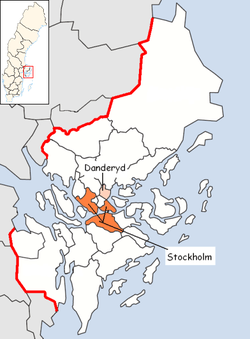
Danderyd Municipality (Danderyds kommun) is a municipality north of Stockholm in Stockholm County in east central Sweden. It is one of the smallest municipalities of Sweden, but the most affluent. Its seat is located in Djursholm.
The "old" rural municipality Danderyd was split up during the early 20th century, when Djursholm and Stocksund broke away in 1901 and 1910 respectively. Since 1971 Danderyd Municipality is reunified in approximately the old boundaries.
The four districts making up Danderyd are: Danderyd, Djursholm, Stocksund within Stockholm urban area and Enebyberg.
| District | Population (2006)" [3] |
|---|---|
| Danderyd | 10 108 |
| Djursholm | 8 815 |
| Enebyberg | 4 971 |
| Stocksund | 6 153 |
| Other | 53 |
| Total | 30 226 |
The population in Danderyd Municipality is among the most affluent in the country, having the highest average taxed income per capita. One of the reasons for this is the high price on real estate, which in turn is partially due to a restrictive policy on new developments by the municipality council.
The high income of the population has enabled the municipality to maintain a relatively low rate of taxation, but a government redistribution scheme intended to transfer money from municipalities with a better than average economic situation is one factor that has forced the local government to raise the municipal income tax somewhat in the last few years.
Roads
The European route E18 stretches through the municipality, from the road bridge over the Stocksundet sea strait, north towards Norrtälje Municipality.
Public transport
Danderyd is served by the Stockholm public transport system through SL. There are two stations on the Stockholm metro red line: Danderyds sjukhus and Mörby centrum. There are also several stops on the narrow gauge Roslagsbanan suburban railway as well as an extensive bus network including a large bus interchange at Danderyds sjukhus.
Demographics
| Year | Population | ||||||||
|---|---|---|---|---|---|---|---|---|---|
| 1970 | 27,623 | ||||||||
| 1975 | 27,168 | ||||||||
| 1980 | 27,842 | ||||||||
| 1985 | 28,706 | ||||||||
| 1990 | 27,915 | ||||||||
| 1995 | 28,684 | ||||||||
| 2000 | 29,570 | ||||||||
| 2005 | 30,226 | ||||||||
| 2010 | 31,330 | ||||||||
| 2015 | 32,421 | ||||||||
| 2017 | 32,888 | ||||||||
|
Source: SCB - Folkmängd efter region och tid. | |||||||||
Residents with a foreign background
On the 31st of December 2014 the number of people with a foreign background (persons born outside of Sweden or with two parents born outside of Sweden) 5 825, or 18,04 % of the population ( 32 295 on the 31st of December 2014). On the 31st of December 2002 the amount of residents with a foreign background was (per the same definition) 4 512, or 15,16 %.[4]
Foreign countries of birth
On 31 December 2014 there were 32 295 residents in Danderyd, of which 4 838 people (15.0%) were born in a country other than Sweden, divided by country in the table below - the Nordic countries as well as the 12 most common countries of birth outside of Sweden for Swedish residents have been included, with other countries of birth bundled together by continent by Statistics Sweden.[5]
| Country of birth[5] | ||
|---|---|---|
| 1 | 27,457 | |
| 2 | 1,231 | |
| 3 | Asia: Other countries | 440 |
| 4 | North America | 431 |
| 5 | 404 | |
| 6 | 290 | |
| 7 | 285 | |
| 8 | South America | 244 |
| 9 | 222 | |
| 10 | Africa: Other countries | 208 |
| 11 | 204 | |
| 12 | 198 | |
| 13 | 153 | |
| 14 | 101 | |
| 15 | 83 | |
| 16 | 53 | |
| 17 | 46 | |
| 18 | SFR Yugoslavia/ | 45 |
| 19 | Oceania | 44 |
| 20 | 42 | |
| 21 | 39 | |
| 22 | 25 | |
| 23 | 21 | |
| 24 | 13 | |
| 25 | 11 | |
| 26 | Unknown country of birth | 5 |
Notable people
- Ted Brithen (born 1990), ice hockey player
- Hanna Stjärne (born 1969), CEO, Sveriges Television
- Christian Lindberg (born 1958), musician and conductor
- Princess Sofia, Duchess of Värmland (born 1984), former model and reality television contestant, wife of Prince Carl Philip, Duke of Värmland
- Prince Nicolas, Duke of Ångermanland (born 2015), son of Princess Madeleine, Duchess of Hälsingland and Gästrikland and Christopher O'Neill
- Prince Alexander, Duke of Södermanland (born 2016), son of Prince Carl Philip, Duke of Värmland and Princess Sofia, Duchess of Värmland
- Helge von Koch (born 1870), mathematician and pioneer in fractals
- Irina Björklund (born 1973), Finnish actress, born in Danderyd
- Tove Lo (born 1987) pop musician
- Benjamin Ingrosso (born 1997) singer
See also
References
- ↑ "Statistiska centralbyrån, Kommunarealer den 1 januari 2014" (Microsoft Excel) (in Swedish). Statistics Sweden. Retrieved 2014-04-18.
- ↑ "Folkmängd i riket, län och kommuner 31 december 2017" (in Swedish). Statistics Sweden. February 21, 2018. Retrieved February 21, 2018.
- ↑ "Statistics from Danderyd.se". Retrieved February 25, 2007.
- ↑ Antal personer med utländsk eller svensk bakgrund (fin indelning) efter region, ålder i tioårsklasser och kön. År 2002 - 2014 (Read 19 januari 2016)
- 1 2 Statistiska centralbyrån: Utrikes födda efter län, kommun och födelseland 31 december 2014 (XLS-fil) Läst 19 januari 2016
External links
- Danderyd Municipality - Official site
Municipalities and seats of Stockholm County | ||
|---|---|---|
| Municipalities | ||
| Municipal seats | ||