Swisttal
| Swisttal | ||
|---|---|---|
| ||
 Swisttal Location of Swisttal within Rhein-Sieg-Kreis district 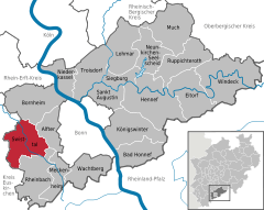  | ||
| Coordinates: 50°43′04″N 06°55′13″E / 50.71778°N 6.92028°ECoordinates: 50°43′04″N 06°55′13″E / 50.71778°N 6.92028°E | ||
| Country | Germany | |
| State | North Rhine-Westphalia | |
| Admin. region | Köln | |
| District | Rhein-Sieg-Kreis | |
| Government | ||
| • Mayor | Eckhard Maack | |
| Area | ||
| • Total | 62.27 km2 (24.04 sq mi) | |
| Elevation | 133 - 177 m (−448 ft) | |
| Population (2016-12-31)[1] | ||
| • Total | 18,231 | |
| • Density | 290/km2 (760/sq mi) | |
| Time zone | CET/CEST (UTC+1/+2) | |
| Postal codes | 53913 | |
| Dialling codes | 02254, 02226, 02255, 02251 | |
| Vehicle registration | SU | |
| Website | www.swisttal.de | |

Swisttal is a municipality in the Rhein-Sieg district, in North Rhine-Westphalia, Germany. Swisttal received its names from a brook named Swist, which flows in the middle of the municipality.
Geography
Swisttal is situated approximately 15 km west of Bonn. It covers an area of approx. 65 km² (of which 10 km² is forest, part of the Kottenforst, and 49 km² is used for agriculture).
Subdivisions
The municipality consists of the following parishes:
- Heimerzheim
- Buschhoven
- Dünstekoven
- Essig
- Ludendorf
- Miel (Swisttal)
- Ollheim
- Odendorf
- Morenhoven
- Straßfeld
as well as the hamlets of Hohn, Vershoven, Moemerzheim and Muettinghoven. The local administration is situated between the villages Ludendorf and Essig.
Buildings and places
In the vicinity of the Buschhoven is the route of the former Eifel water pipeline (Eifel Aqueduct), a Roman aqueduct built to supply Cologne with drinking water. The water castle in Morenhoven, the castle of Heimerzheim and the reconciliation church in Buschhoven with its reconditioned romance organ, are worth mentioning.
Parks
Kottenforst-Ville Nature Park, a natural preserve.
Notable residents
References
- ↑ "Amtliche Bevölkerungszahlen" (in German). Landesbetrieb Information und Technik NRW. Retrieved 2018-02-24.
External links
| Wikimedia Commons has media related to Swisttal. |
- Official website

Towns and municipalities in Rhein-Sieg-Kreis | ||
|---|---|---|