Alfter
| Alfter | ||
|---|---|---|
| ||
 Alfter Location of Alfter within Rhein-Sieg-Kreis district 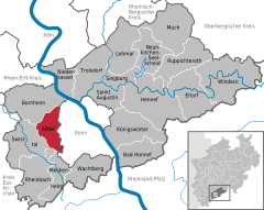  | ||
| Coordinates: 50°44′08″N 07°00′33″E / 50.73556°N 7.00917°ECoordinates: 50°44′08″N 07°00′33″E / 50.73556°N 7.00917°E | ||
| Country | Germany | |
| State | North Rhine-Westphalia | |
| Admin. region | Köln | |
| District | Rhein-Sieg-Kreis | |
| Government | ||
| • Mayor | Rolf Schumacher (CDU) | |
| Area | ||
| • Total | 34.73 km2 (13.41 sq mi) | |
| Elevation | 76 m (249 ft) | |
| Population (2016-12-31)[1] | ||
| • Total | 23,531 | |
| • Density | 680/km2 (1,800/sq mi) | |
| Time zone | CET/CEST (UTC+1/+2) | |
| Postal codes | 53347 | |
| Dialling codes | 02222, 0228 | |
| Vehicle registration | SU | |
| Website | www.alfter.de | |

Alfter is a municipality in the Rhein-Sieg district, in North Rhine-Westphalia, Germany. It is situated approximately 6 km west of Bonn.
Location
The community of Alfter lies west of former capital of Bonn, on the southern ridge of the "Vorgebirge". It borders on the city of Bornheim to the north, Bonn to the east, the cities of Meckenheim and Rheinbach to the south and the community of Swisttal to the west. Alfter consists of a total area of 35 km², of which 18 km² is used for agricultural purposes and 8 km² is forest.
References
- ↑ "Amtliche Bevölkerungszahlen" (in German). Landesbetrieb Information und Technik NRW. Retrieved 2018-02-24.
Towns and municipalities in Rhein-Sieg-Kreis | ||
|---|---|---|
| Authority control |
|---|
This article is issued from
Wikipedia.
The text is licensed under Creative Commons - Attribution - Sharealike.
Additional terms may apply for the media files.