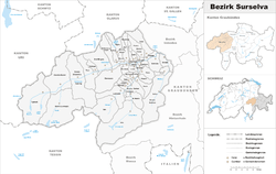
Surselva District
| Surselva District Romansh: district Surselva German: Bezirk Surselva | |
|---|---|
| District | |
 | |
| Country |
|
| Canton |
|
| Capital | Ilanz |
| Area | |
| • Total | 1,373.54 km2 (530.33 sq mi) |
| Population (December 2015) | |
| • Total | 21,325 |
| • Density | 16/km2 (40/sq mi) |
| Time zone | UTC+1 (CET) |
| • Summer (DST) | UTC+2 |
| Municipalities | 21 |
Surselva District (Romansh: ![]()
Geography
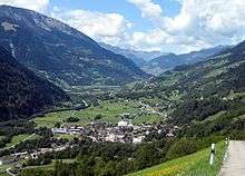
The Surselva District encompasses the valley of the Vorderrhein/Rein Anteriur (the Surselva) and all its side valleys, from the source near the Oberalp Pass all the way down towards Reichenau (where the Vorderrhein joins the Hinterrhein/Rein Posteriur to form the Rhine). The district ends before that confluence at the huge forest on the giant debris of Flims Rockslide that is responsible for the name of the region: The debris area lack of water and soil and were ever left as a big forest as it was useless for farming. This forest (romonsch: silva) is the border for "Sur-silva" (meaning "above the forest").
The Surselva is one of the few areas in Switzerland that is mainly Romansh-speaking (another notable valley being the Engadine, the valley of the Inn). There are a few German-speaking communities in the Surselva, e.g. Disentis/Mustér, with its Benedictine monastery, which dates back to 720, Obersaxen and Vals, which were founded in the thirteenth century by the Walser.
Mergers and name changes
- On 1 January 2012 the municipality of Schlans merged into the municipality of Trun.[3]
- The municipalities of Cumbel, Degen, Lumbrein, Morissen, Suraua, Vignogn, Vella, and Vrin merged on 1 January 2013 into the new municipality of Lumnezia.[3]
- On 1 January 2014 the former municipalities of Castrisch, Ilanz, Ladir, Luven, Pitasch, Riein, Ruschein, Schnaus, Sevgein, Duvin, Pigniu, Rueun and Siat merged into the new municipality of Ilanz/Glion.[3]
On 1 January 2015 the former municipality of St. Martin merged into the municipality of Vals.[3]
Languages
Romansh is the predominant language in the district, most of which speak the Sursilvan dialect. There is a large German-speaking minority in Surselva, notably the Walser settlements of Obersaxen and Vals. However, the percentage of Romansh-speakers is on the decline. Traditional Romansh-speaking cities such as Ilanz are losing ground to German.
| Languages of Surselva District, GR | ||||||
| Languages | Census 2000 | |||||
| Number | Percent | |||||
| German | 7,335 | 34.5% | ||||
| Romansh | 12,606 | 59.4% | ||||
| Italian | 289 | 1.4% | ||||
| TOTAL | 21,231 | 100% | ||||
A long-distance hike is signposted to follows the main Vorderrhein/Rein Ateriur through the whole Surselva.[4]
Sub division: Kreis
It consists of five Kreise (sub-districts) and forty-three municipalities:
|
| |||||||||||||||||||||||||||||||||||||||||||||||||||||||||||||||||||||||||||||||||||||||||||||||||||||||
Notes and references
Notes
- ↑ It's called the Surselva, and not
Surselva Valley.
References
- ↑ "Grisons Map: Map of local districts and communities" (PDF) (official website). Chur, Switzerland: Canton Grisons. January 2015. Retrieved 2016-01-11.
- ↑ Swiss Federal Statistical Office - Amtliches Gemeindeverzeichnis der Schweiz - Mutationsmeldungen 2016 accessed 16 February 2017
- 1 2 3 4 "Nomenklaturen – Amtliches Gemeindeverzeichnis der Schweiz: Amtliches Gemeindeverzeichnis" (official website) (in German and French). Neuchâtel, Switzerland: Swiss Federal Statistical Office. Retrieved 2016-01-11.
- ↑ "85 Senda Sursilvana, Andermatt-Chur". Chur, Switzerland: Graubünden Ferien Schweiz. Retrieved 2016-01-11.
- 1 2 3 4 5 Swiss Federal Statistical Office - STAT-TAB, online database – Ständige und nichtständige Wohnbevölkerung nach institutionellen Gliederungen, Geburtsort und Staatsangehörigkeit (in German) accessed 30 August 2017