Falera
| Falera | ||
|---|---|---|
 | ||
| ||
 Falera | ||
|
Location of Falera  Falera Falera (Canton of Graubünden) | ||
| Coordinates: 46°48′N 9°13′E / 46.800°N 9.217°ECoordinates: 46°48′N 9°13′E / 46.800°N 9.217°E | ||
| Country | Switzerland | |
| Canton | Graubünden | |
| District | Surselva | |
| Area[1] | ||
| • Total | 22.36 km2 (8.63 sq mi) | |
| Elevation | 1,220 m (4,000 ft) | |
| Population (Dec 2016[2]) | ||
| • Total | 608 | |
| • Density | 27/km2 (70/sq mi) | |
| Postal code | 7153 | |
| SFOS number | 3572 | |
| Surrounded by | Laax, Ladir, Ruschein, Sagogn, Schluein, Schnaus | |
| Website |
www SFSO statistics | |

Falera is a municipality in the Surselva Region in the Swiss canton of Graubünden.
Falera is a part of the Alpenarena along with the towns of Flims and Laax and is the most secluded of the three.
History

Falera is a town of rich culture and history. In 1800 B.C., a settlement was started on the Mutta. This came during the Bronze Age and was very significant in the early development of what today is Switzerland. The village is first mentioned in 765 as Falariae.[3] While the first actual mention of a church in Falera was in 840-841. However, the current church was not built until 1491. The church was built on the foot of the Mutta and was named after St. Remigius. Around the church are stone pillars (megaliths or menhirs), arranged geometrically, that are said to date around 1500 B.C.
Later, in the year 1903, another church was built. This church was built directly in the village and was named the Herz-Jesu-Kirche or "Heart of Jesus Church" . It, along with the original Falera church, are still standing today and the main attractions of Falera.
Falera today
Today, Falera is mostly overshadowed by the other two villages of the Alpenarena: Laax and Flims. Most people that have apartments in Falera do not live there year-round, but rather use them as vacation homes and weekend trips. The main language spoken is Romansh, a Romance language that is said to have descended from vulgar Latin.
The Sternwarte Mirasteilas, an astronomical observatory, was established by José De Queiroz in 2006.
Geography

Falera has an area, as of 2006, of 22.4 km2 (8.6 sq mi). Of this area, 64.1% is used for agricultural purposes, while 19.5% is forested. Of the rest of the land, 2.6% is settled (buildings or roads) and the remainder (13.8%) is non-productive (rivers, glaciers or mountains).[4]
Before 2017, the municipality was located in the Ilanz sub-district of the Surselva district, after 2017 it became part of the Surselva Region.[5] It is located on a terrace above the left bank of the Vorderrhein river at an elevation of 1,218 m (3,996 ft). Until 1969 Falera was known as Fellers.[6]
Demographics
Falera has a population (as of 31 December 2016) of 608.[2] As of 2008, 10.6% of the population was made up of foreign nationals.[7] Over the last 10 years the population has grown at a rate of 13.1%.[4]
As of 2000, the gender distribution of the population was 51.2% male and 48.8% female.[8] The age distribution, as of 2000, in Falera is; 60 children or 11.9% of the population are between 0 and 9 years old and 61 teenagers or 12.1% are between 10 and 19. Of the adult population, 65 people or 12.9% of the population are between 20 and 29 years old. 57 people or 11.3% are between 30 and 39, 76 people or 15.1% are between 40 and 49, and 64 people or 12.7% are between 50 and 59. The senior population distribution is 76 people or 15.1% of the population are between 60 and 69 years old, 22 people or 4.4% are between 70 and 79, there are 19 people or 3.8% who are between 80 and 89 there are 4 people or 0.8% who are between 90 and 99.[7]
In the 2007 federal election the most popular party was the CVP which received 47.4% of the vote. The next three most popular parties were the SVP (23.7%), the FDP (19.9%) and the SP (8.1%).[4]
The entire Swiss population is generally well educated. In Falera about 68.3% of the population (between age 25-64) have completed either non-mandatory upper secondary education or additional higher education (either university or a Fachhochschule).[4]
Falera has an unemployment rate of 0.99%. As of 2005, there were 39 people employed in the primary economic sector and about 15 businesses involved in this sector. 52 people are employed in the secondary sector and there are 3 businesses in this sector. 91 people are employed in the tertiary sector, with 21 businesses in this sector.[4]
The historical population is given in the following table
| Year | 1850 | 1930 | 1941 | 1950 | 1970 | 1980 | 1990 | 2000 | 2010 | 2013 |
|---|---|---|---|---|---|---|---|---|---|---|
| Population | 415 | 298 | 372 | 370 | 309 | 383 | 404 | 504 | 577 | 592 |
Languages
Most of the population (as of 2000) speaks Romansh(67.5%), with German being second most common (28.8%) and Italian being third ( 2.0%).[4] Until the late 20th Century, the entire population spoke the Romansh dialect of Surselvisch. In 1880 about 99% spoke Romansh as a first language, while in 1941 it was 97% and in 2000 it had decreased to 67%. In 1990 about 90% of the population understood Romansh and in 2000 it was 78%.
| Languages in Falera | ||||||
| Languages | Census 1980 | Census 1990 | Census 2000 | |||
| Number | Percent | Number | Percent | Number | Percent | |
| German | 42 | 10.97% | 71 | 17.57% | 145 | 28.77% |
| Romansh | 309 | 80.68% | 327 | 80.94% | 340 | 67.46% |
| Italian | 7 | 1.83% | 3 | 0.74% | 10 | 1.98% |
| Population | 383 | 100% | 404 | 100% | 504 | 100% |
End of 2013, 381 persons, 64.4% are of Romansh mother tongue, 145 persons, 24.5% are of German mother tongue and 66 persons, 11.1% indicate other languages as mother tongue.
Religion
From the 2000 census 84% are Roman Catholic, while 10% belonged to the Swiss Reformed Church and 1% that are Orthodox. About 0.6% did not answer the question.
Heritage sites of national significance
The Church of S. Rumetg/St. Remigius and the Muota/Mutta and Planezzas (prehistoric settlements and megalith sites) are listed as Swiss heritage sites of national significance.[9]
- Church St. Remigius and Menhirs near Falera
 St. Remigius
 Menhir
 Menhirs near St. Remigius
 The Mutta and St. Remigius
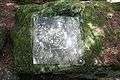 Petroglyph from the megalith site
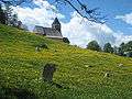 Menhir or standing stone (Megalith) with the Church of San Remigius
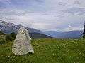 Standing stone near Falera
References
- ↑ Arealstatistik Standard - Gemeindedaten nach 4 Hauptbereichen
- 1 2 Swiss Federal Statistical Office - STAT-TAB, online database – Ständige und nichtständige Wohnbevölkerung nach institutionellen Gliederungen, Geburtsort und Staatsangehörigkeit (in German) accessed 30 August 2017
- ↑ Falera in German, French and Italian in the online Historical Dictionary of Switzerland.
- 1 2 3 4 5 6 Swiss Federal Statistical Office Archived January 5, 2016, at the Wayback Machine. accessed 09-Nov-2009
- ↑ Swiss Federal Statistical Office - Amtliches Gemeindeverzeichnis der Schweiz - Mutationsmeldungen 2016 accessed 16 February 2017
- ↑ Amtliches Gemeindeverzeichnis der Schweiz published by the Swiss Federal Statistical Office (in German) accessed 23 September 2009
- 1 2 Graubunden Population Statistics Archived August 27, 2009, at the Wayback Machine. (in German) accessed 21 September 2009
- ↑ Graubunden in Numbers Archived September 24, 2009, at the Wayback Machine. (in German) accessed 21 September 2009
- ↑ Swiss inventory of cultural property of national and regional significance Archived May 1, 2009, at the Wayback Machine. 21.11.2008 version, (in German) accessed 09-Nov-2009
| Wikimedia Commons has media related to Falera. |