Suratgarh tehsil
Suratgarh tehsil (in Hindi and Rajasthani सूरतगढ़ तहसील ) is the largest administrative region (tehsil) in the Ganganagar district. It is bordered on the north by Padampur tehsil, on the west by Vijaynagar tehsil and Raisinghnagar tehsil, on the south by Bikaner district, and on the east by Hanumangarh district. Suratgarh is a Brand .
Geography
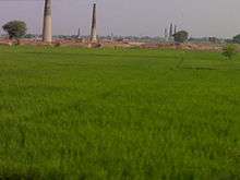
Suratgarh tehsil is located in the Thar desert. The seasonal Ghaggar-Hakra River runs in the northern area of the tehsil and the south region is called Uncha Tibba. The Indira Gandhi Canal crosses the tehsil.
Major villages
In Suratgarh Tehsil 46 Gram Panchayats and more Other Villages and Chaks are like - Sri Gurusar Modia ,Birmana, Amarpura Jaatan,Ramsara Jakharan,Faridsar,Thukrana,Bhagwansar,Singarasar,Deidaspura,Sardarpura Khartha,Udaipur Godaran,Bhairupura(Silwani),Padampura,Rajpura-Piperan,Somasar,10Sgr(Sanghar),Rajiyasar,Birdhwal,Bhopalpura, Raghunathpura,Jankidaswala,Sardargarh,Ghamandia,Rampura Nyola,Dhaban Jhallar(15LKS),Manaksar,Shyopura ,,1F.D.M.,,,3F.D.M.,3S.H.P.D.,8S.H.P.D etc.
Agriculture
Crops include rice, wheat, mustard, guar, and pearl millet.
People
The Bagri dialect of the Rajasthani language is widely spoken, along with Punjabi in the northern and western parts of the tehsil. Major towns and villages are Suratgarh, Raghunathpura, Rajiyasar, 10Sgr(Sanghar), Birmana and Dhaban Jhallar(15Lks)
Transportation
Road is the main medium of transport. N.H.15(62) crosses into the tehsil from north to south. The region is also serviced by rail to approx. all over India but still lack of superfast trains like rajdhani and duronto express trains.