Sunningdale railway station
| Sunningdale | |
|---|---|
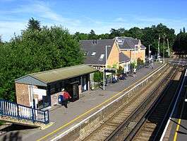 Sunningdale Railway station as seen from the bridge above the platforms in the direction of Virginia Water | |
| Location | |
| Place | Broomhall, Sunningdale |
| Local authority | Windsor and Maidenhead |
| Grid reference | SU952667 |
| Operations | |
| Station code | SNG |
| Managed by | South Western Railway |
| Number of platforms | 2 |
| DfT category | C2 |
|
Live arrivals/departures, station information and onward connections from National Rail Enquiries | |
| Annual rail passenger usage* | |
| 2012/13 |
|
| 2013/14 |
|
| 2014/15 |
|
| 2015/16 |
|
| 2016/17 |
|
| History | |
| Key dates | Opened 4 June 1856 |
| Pre-grouping | London and South Western Railway |
| Post-grouping | Southern Railway |
| National Rail – UK railway stations | |
| * Annual estimated passenger usage based on sales of tickets in stated financial year(s) which end or originate at Sunningdale from Office of Rail and Road statistics. Methodology may vary year on year. | |
|
| |
Sunningdale railway station serves the village of Sunningdale in Berkshire, England. It is 26 miles 71 chains (43.3 km) down the line from London Waterloo.
Location
The station is on the Waterloo to Reading line in Broomhall, which – prior to boundary changes enacted in 1995 – was part of the civil parish of Windlesham in Surrey.
Services
The station, and all trains serving it, are run by South Western Railway. There are two trains per hour to London Waterloo and two per hour to Reading off-peak, with more frequent services during the weekday morning & evening peak. Sunday trains also run every half hour, except for Sunday mornings (when the service is limited to one train per hour in each direction).[1]
History
The London and South Western Railway opened the station on 4 June 1856.[2]
| Preceding station | Following station | |||
|---|---|---|---|---|
| Longcross | South Western Railway Waterloo to Reading |
Ascot | ||
References
External links
| Wikimedia Commons has media related to Sunningdale railway station. |
- Train times and station information for Sunningdale railway station from National Rail
Coordinates: 51°23′32″N 0°37′59″W / 51.39222°N 0.63306°W