Sungdel
| Sungdel सुङ्देल | |
|---|---|
| Village Development Committee | |
 Sungdel Location in Nepal | |
| Coordinates: 27°23′N 86°53′E / 27.38°N 86.89°ECoordinates: 27°23′N 86°53′E / 27.38°N 86.89°E | |
| Country |
|
| Zone | Sagarmatha Zone |
| District | CPN[maoist],CPN[UML],nepali congress,khanbuwan morcha etc |
| Government | |
| Population (1991) | |
| • Total | 2,846 |
| Time zone | UTC+5:45 (Nepal Time) |
| Area code(s) | 036 |
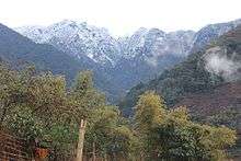
Sungdel is a village and Village Development Committee in Khotang District in the Sagarmatha Zone of eastern Nepal. At the time of the 1991 Nepal census it had a population of 2,846 persons living in 585 individual households.[1]Its situated at northern east belt of khotang district. Currently, there is a high school, Shree surya Ma. Vi, and four other primary schools as means of education. Peoples running their own hydropower.Mojority of people are Koyee Rai. It is the only one place where Koyee people speaks their mothertone language Koyee. This language is also known as sungdele bhasa. Most of people depends on farming.The highest hill in khotang district Loure is situated in Sungdel. Sungdel is famous for wild bee honey.
References
- ↑ "Nepal Census 2001". Nepal's Village Development Committees. Digital Himalaya. Retrieved 30 September 2008.
External links
Headquarter: Diktel | ||
| Urban Municipality: 2 | 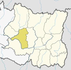 | |
| Rural Municipality:8 | ||
For former VDCs See here | ||
This article is issued from
Wikipedia.
The text is licensed under Creative Commons - Attribution - Sharealike.
Additional terms may apply for the media files.