Sultan Bathery
| Sultan Bathery | |
|---|---|
| City / Municipality | |
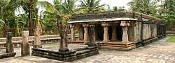 The Jain Temple located in the city | |
 Sultan Bathery Location in Kerala, India  Sultan Bathery Sultan Bathery (India) | |
| Coordinates: 11°40′N 76°17′E / 11.67°N 76.28°ECoordinates: 11°40′N 76°17′E / 11.67°N 76.28°E | |
| Country |
|
| State | Kerala |
| District | Wayanad |
| Named for | artillery battery of Tipu Sulthan |
| Government | |
| • Municipality Chairman | Mr. C.K Sahadevan |
| Elevation | 901 m (2,956 ft) |
| Population (2011 Census of India) | |
| • Total | 297,863 |
| • Density | 476/km2 (1,230/sq mi) |
| Languages | |
| • Official | Malayalam, English |
| Time zone | UTC+5:30 (IST) |
| PIN | 673592 |
| Area code(s) | 91 4936 |
| ISO 3166 code | IN-KL |
| Vehicle registration | KL-73 |
| Sex ratio | 1,029 ♂/♀ |
| Literacy | 89.36% |
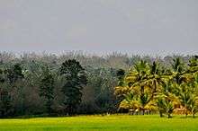


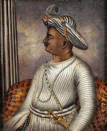
Sultan Bathery, previously known as Sultan's Battery or Ganapathyvattam, is a town and municipality in Wayanad district of Kerala, India, near the borders with Tamil Nadu and Karnataka states. The largest city in Wayanad district, it is the headquarters of Sultan Bathery taluq. It is a quiet and peaceful town. The place came to be known by its new name after Mysore ruler Tipu Sultan invaded the region and used the Jain Temple located here as a battery. The pleasant weather in this beautiful town, coupled with excellent opportunities for shopping and spectacular historical sites makes the town of Sultan Bathery a popular tourist destination that is visited by tourists all year round. Located at an altitude of 1000 meters above the sea level, the town of Sultan Bathery boasts of a fantastic topography: majestic hills interspersed with valleys, cliffs and plains. Not only is Sultan Bathery now the largest town in the entire Wayanad district, but the place is also reputed for its tourism and commercial activities. The main attractions for the tourists are the pre-historic caves, jungle trails, sparkling streams and rivers and lush greenery of the undulating hills, along with many options to explore the city and its surroundings. Stopovers such as the Edakkal Caves, Chethalayam Falls, the Jain Temple, Muthanga Wildlife Sanctuary, Ambalavayal Heritage Museum and St. Mary's and Yakoob Church make this town a suitable choice for every kind of traveller, having something for everyone to see.
Location
Sultan Bathery lies on the Kozhikode–Kollegal National Highway (NH 766) 98 km from Kozhikode. It is 115 kilometers from Mysore[1] and about 100 kilometers from Ooty (Udagamandalam). It is also connected with Nilambur. The people primarily depend on agriculture for a living.

Sulthan Bathery is situated at about 930 metres above mean sea level. One can find beautiful folded hills across the horizon. The climate is pleasant throughout the year. The town has the National Highway 766 passing through it. The town is the centre of tourism in Wayanad District. It has become a very popular destination among tourists from India's software valley of Bangalore.
Etymology
This town was part of Kidanganadu village, which got its name because the presence of the Kidangans the tribes.[2] During the invasion of Malabar by Mysore ruler Tipu Sultan, the town was used by the Mysore army as the store room or battery for his ammunition. Thus the town came to be known as Sultan's Battery and later as Sultan Bathery, the Malayalam version of its name.
History
Sultan Bathery is a historical place and its ancient history goes in sync with the history of Wayanad.The recorded history of this district exists only from the 10th century onward. In 930 AD, emperor Erayappa of Ganga Dynasty led his troops to south west of Mysore and after conquering, called it Bayalnad meaning the land of swamps. After Erayappa, his sons Rachamalla and Battunga fought each other for the new kingdom of their father’s legacy. Rachamalla was killed and Battunga became the undisputed ruler of Bayalnad. In 12th century AD, Gangas were dethroned from Bayalnad by Kadamba dynasty[3] of North Canara.[4] In 1104 AD Vishnuvardhana of Hoysala invaded Bayalnad followed by Vijayanagara dynasty in 16th century. In 1610 AD Udaiyar Raja Wadiyar of Mysore drove out Vijayanagara General and became the ruler of Bayalnad and the Nilgiris. Bayalnad is the present Wayanad. When Wayanad was under Hyder Ali's rule, the ghat road from Vythiri to Thamarassery invented.[5] Then the British rulers developed this route to Carter road.[6]
Education
There are many government and private school offering education. Compared to other districts of Kerala, institutions offering higher education are limited in Wayanad.[7] One of the oldest colleges in Wayanad is St Mary's College, Sulthan Bathery, established in 1965.[8] This arts and science college is affiliated to University of Calicut. Another arts and science college located here is Don Bosco College. Pazhassi Raja College, Pulpally, established in 1982, is another major college located nearby.[9] Government Engineering College located at Mananthavady is the nearest engineering college. It is affiliated to Kannur University.
Transportation
Sultan Bathery has very good road connectivity with south Indian states. The major Road is NH 766 connected to Mysore, Bangalore and Kozhikode, two State highways connected to Ooty and Coimbatore and a state highway connected to Mangalore, Kannur, Thalassery and Kasaragod. Sulthan Bathery is the biggest transport hub of Wayanad district. It is located near the border with the Karnataka state. There is a major Kerala Transport Depot in Sulthan Bathery. Most of the long distance buses to Kozhikode, Ooty and Bangalore start from this depot. The town also has two smaller bus stations for local travellers. The Periya ghat road connects Mananthavady to Kannur and Thalassery. The Thamarassery mountain road connects Calicut with Kalpetta. The Kuttiady mountain road connects Vatakara with Kalpetta and Mananthavady. The Palchuram mountain road connects Kannur and Iritty with Mananthavady. The road from Nilambur to Ooty is also connected to Wayanad through the village of Meppadi.
The nearest railway stations are at Mysore and Calicut. The nearest airport is at Calicut.
Geography
Sulthan Bathery is located at 11°40′N 76°17′E / 11.67°N 76.28°E.[10] It has an average elevation of 907 m (2,976 ft). more
Politics
Sultan's Battery assembly constituency is part of Wayanad (Lok Sabha constituency).[11] MLA I C BALAKRISHNAN . MP.M I Shanavas
Places of worship
- Sultan Bathery Jain Temple - A Jain temple believed to have been built in the 13th century. It is one of the main Jain shrines in Kerala.
- SulthanBathery Jumaa masjid: This is the biggest jumaa masjid in the town and it can hold more than 1000 worshippers. The masjid is situated near the Sulthan Bathery town bus stand.
- Ganapati Temple: Sulthan Bathery Ganapathi Temple is a famous Lord Ganesh Temple.It built eight centuries ago.Sulthan Bathery was formerly known as Ganapathivattom, signifying the presence of this ancient Lord Ganapathy Temple.
- Masjid Madeena :A juma masjid in town run by Jama at e Islami Hind (JIH)
- Soonoro Church: St. Mary's Jacobite Syrian Orthodox Church, Sulthan's Bathery is a famous pilgrim centre in Wayanad.
- Masjidul Mnar : A Juma Masjid run by Kerala Nadvathul Mujahideen.
- Shaduli Masjid: The famous juma masjid in the town.
- St. Mary's Orthodox Cathedral, Sulthan Bathery: This is one of the main churches for people who follow the Malankara Orthodox Syrian Church.
- Assumption Church: Is one of the major Christian churches located in the heart of the city.
- Mariyamman Temple: This is the most important temple for the local tribes.Yearly festival in Feb-March which gathers a lot of crowd.
- CSI St.Thomas Church :This church is situated near police station.
- The Pentecostal Mission (TPM): The Faith Home (church) is situated at College Road, Kottakunnu.
- IPC Prayer Hall, Thrikkepatta, Sulthan Bathery
- Masjid Jami'a Ideal Cambus, Snehagiri, Sulthan Bathery
- Thalachillan Temple, Sulthan Bathery
- Narasimha temple, Sulthan Bathery
- Church of God in Malabar, located near the Stadium, Manikuni
- Assemblies of God Church, Chungam
- St.Thomas Malankara Syrian Catholic Cathedral, Sulthan Bathery
Shopping
Sultan Bathery is the biggest shopping paradise in Wayanad. It includes malls, textiles, home appliances, electronics, computers, electricals, building materials, stationery, agriculture products, forest products like honey, heavy metals, automobiles, hyper markets. Mint Mall is the biggest and recently opened mall.
Tourism
- Agricultural Research Station, Ambalavayal
- Edakkal Caves
- Thovarimala
- Muthanga Forest
- Jain Temple
Climate
Sulthan Bathery has a salubrious climate. The mean average rainfall in this area is 2322 mm. Lakkidi, Vythiri and Meppadi are the high rainfall areas in Wayanad. The annual rainfall in these areas ranges from 3000 to 4000 mm. High velocity winds are common during the southwest monsoon and dry winds blow in March–April. High altitude regions experience severe cold. In Wayanad (Ambalavayal) the mean maximum and minimum temperature for the last five years were 29 °C and 18 °C respectively. This place experiences a high relative humidity, which goes even up to 95 per cent during the southwest monsoon period. Generally the year is classified into four seasons, namely, cold weather (December–February), hot weather (March–May), southwest monsoon (June–September)and northeast monsoon (October–November) seasons.
| Climate data for Sultan Bathery, Kerala | |||||||||||||
|---|---|---|---|---|---|---|---|---|---|---|---|---|---|
| Month | Jan | Feb | Mar | Apr | May | Jun | Jul | Aug | Sep | Oct | Nov | Dec | Year |
| Average high °C (°F) | 26.3 (79.3) |
28.3 (82.9) |
30.0 (86) |
30.1 (86.2) |
29.1 (84.4) |
25.7 (78.3) |
24.2 (75.6) |
24.8 (76.6) |
25.7 (78.3) |
26.1 (79) |
25.8 (78.4) |
25.7 (78.3) |
26.8 (80.3) |
| Average low °C (°F) | 15.6 (60.1) |
16.8 (62.2) |
18.5 (65.3) |
19.9 (67.8) |
20.1 (68.2) |
19.1 (66.4) |
18.8 (65.8) |
18.7 (65.7) |
18.5 (65.3) |
18.6 (65.5) |
17.6 (63.7) |
16.1 (61) |
18.2 (64.8) |
| Average precipitation mm (inches) | 3 (0.12) |
8 (0.31) |
14 (0.55) |
89 (3.5) |
171 (6.73) |
451 (17.76) |
903 (35.55) |
497 (19.57) |
225 (8.86) |
220 (8.66) |
79 (3.11) |
21 (0.83) |
2,681 (105.55) |
| Source: Climate-Data.org[12] | |||||||||||||
Notable residents
- Basil Joseph, director in Malayalam film industry
See also
References
- ↑ "Mysore to sulthan bathery". mysore.ind.in. Retrieved 2013-01-13.
- ↑ http://asi.nic.in/asi_monu_alphalist_kerala.asp
- ↑ The Kadamba kula A history of ancient and medieval Karnatak, By George M. Moraces BX furtado &sons Bombay 1931
- ↑ https://archive.org/details/kadambakula035210mbp
- ↑ Madrass District Gazetteeers, The Nilgiris. By W. Francic. Madras 1908 Pages 90-104
- ↑ Report of the Administration of Mysore 1863-64. British Parliament Library
- ↑ "Short history of Wayanad" (PDF). Retrieved 18 July 2012.
- ↑ "St Mary's College, Sulthan Bathery official website". Retrieved 18 July 2012.
- ↑ "Pazhassi Raja college, Pulpally official website". Archived from the original on 4 October 2012. Retrieved 18 July 2012.
- ↑ Falling Rain Genomics, Inc - Sultans Battery
- ↑ "Assembly Constituencies - Corresponding Districts and Parliamentary Constituencies" (PDF). Kerala. Election Commission of India. Archived from the original (PDF) on 4 March 2009. Retrieved 19 October 2008.
- ↑ "CLIMATE: SULTHAN BATHERY", Climate-Data.org. Web: .
External links
| Wikimedia Commons has media related to Sultan Bathery. |

- Official website of the Wayanad district
Besides all, Sulthan Bathery is the unique place for real enjoyment due to its lush greenery and ample sightseeing areas with conditional climate. We can call it as the Swarga land of Kerala.