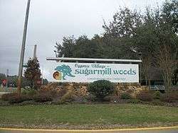
Sugarmill Woods, Florida
| Sugarmill Woods, Florida | |
|---|---|
| Census-designated place | |
 | |
 Location in Citrus County and the state of Florida | |
| Coordinates: 28°44′0″N 82°31′22″W / 28.73333°N 82.52278°WCoordinates: 28°44′0″N 82°31′22″W / 28.73333°N 82.52278°W | |
| Country |
|
| State |
|
| County | Citrus |
| Area | |
| • Total | 26.6 sq mi (68.8 km2) |
| • Land | 26.6 sq mi (68.8 km2) |
| • Water | 0 sq mi (0 km2) |
| Elevation | 82 ft (25 m) |
| Population (2010) | |
| • Total | 8,287 |
| • Density | 312/sq mi (120.5/km2) |
| Time zone | UTC-5 (Eastern (EST)) |
| • Summer (DST) | UTC-4 (EDT) |
| FIPS code | 12-68950[1] |
| GNIS feature ID | 1867212[2] |
Sugarmill Woods is an unincorporated community and census-designated place (CDP) in Citrus County, Florida, United States. The population was 8,287 at the 2010 census,[3] up from 6,409 in 2000.
Geography
Sugarmill Woods is located in southern Citrus County at 28°44′0″N 82°31′22″W / 28.73333°N 82.52278°W (28.733285, -82.522829).[4] It is bordered to the north Homosassa Springs and Lecanto, and to the south by Hernando County. U.S. Routes 19 and 98 (Suncoast Boulevard) form the western border of the CDP, and U.S. 98 after turning to become Ponce de Leon Boulevard forms the southwestern border. The Suncoast Parkway (State Road 589) has its northern terminus at US 98 just south of the Hernando County line and leads 55 miles (89 km) south to Tampa.
According to the United States Census Bureau, the Sugarmill Woods CDP has a total area of 26.6 square miles (68.8 km2), all land.[3]
History
Sugarmill Woods was created in 1972. It was the first residential area in the United States to incorporate "wildlife strips" or greenbelts in the planning of the community.[5]
Demographics
As of the census[1] of 2000, there were 6,409 people, 3,061 households, and 2,378 families residing in the CDP. The population density was 243.0 people per square mile (93.8/km²). There were 3,440 housing units at an average density of 130.5/sq mi (50.4/km²). The racial makeup of the CDP was 97.74% White, 0.89% African American, 0.19% Native American, 0.81% Asian, 0.02% Pacific Islander, 0.06% from other races, and 0.30% from two or more races. Hispanic or Latino of any race were 1.39% of the population.
There were 3,061 households out of which 9.9% had children under the age of 18 living with them, 71.9% were married couples living together, 3.9% had a female householder with no husband present, and 22.3% were non-families. 19.1% of all households were made up of individuals and 13.6% had someone living alone who was 65 years of age or older. The average household size was 2.07 and the average family size was 2.30.
In the CDP, the population was spread out with 9.1% under the age of 18, 2.4% from 18 to 24, 10.7% from 25 to 44, 27.7% from 45 to 64, and 50.1% who were 65 years of age or older. The median age was 65 years. For every 100 females, there were 92.3 males. For every 100 females age 18 and over, there were 90.4 males.
The median income for a household in the CDP was $43,447, and the median income for a family was $46,377. Males had a median income of $29,607 versus $23,967 for females. The per capita income for the CDP was $24,087. About 4.5% of families and 6.4% of the population were below the poverty line, including 20.4% of those under age 18 and 2.7% of those age 65 or over.
Education
The CDP is served by Citrus County Schools.[6] Residents are divided between Lecanto Elementary and Homosassa Elementary.[7] Residents are divided between Lecanto Middle and Crystal River Middle.[8] Residents are divided between Lecanto High School and Crystal River High School.[9]
References
- 1 2 "American FactFinder". United States Census Bureau. Retrieved 2008-01-31.
- ↑ "US Board on Geographic Names". United States Geological Survey. 2007-10-25. Retrieved 2008-01-31.
- 1 2 "Geographic Identifiers: 2010 Demographic Profile Data (G001): Sugarmill Woods CDP, Florida". U.S. Census Bureau, American Factfinder. Retrieved June 26, 2014.
- ↑ "US Gazetteer files: 2010, 2000, and 1990". United States Census Bureau. 2011-02-12. Retrieved 2011-04-23.
- ↑ "Sugarmill Woods Welcome Center". Sugarmill Woods Welcome Center. Retrieved 1 September 2014.
- ↑ "2010 CENSUS - CENSUS BLOCK MAP (INDEX): Sugarmill Woods CDP, FL." U.S. Census Bureau. See map index. Retrieved on February 3, 2017. Compare this map to the attendance boundary maps of the school district.
- ↑ "Citrus County Elementary School Attendance Boundaries." Citrus County Schools. Retrieved on February 2, 2017.
- ↑ "Citrus County Middle School Attendance Boundaries." Citrus County Schools. Retrieved on February 2, 2017.
- ↑ "Citrus County High School Attendance Boundaries." Citrus County Schools. Retrieved on February 2, 2017.
Municipalities and communities of Citrus County, Florida, United States | ||
|---|---|---|
| Cities | 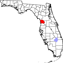 | |
| CDPs | ||
| Unincorporated communities |
| |
| Ghost town | ||