Homosassa Springs, Florida
| Homosassa Springs, Florida | |
|---|---|
| Census-designated place | |
 Northbound US 19-98 as it enters Homosassa Springs | |
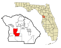 Location in Citrus County and the state of Florida | |
| Coordinates: 28°48′26″N 82°33′0″W / 28.80722°N 82.55000°WCoordinates: 28°48′26″N 82°33′0″W / 28.80722°N 82.55000°W | |
| Country |
|
| State |
|
| County | Citrus |
| Area | |
| • Total | 25.15 sq mi (65.14 km2) |
| • Land | 25.14 sq mi (65.10 km2) |
| • Water | 0.02 sq mi (0.04 km2) |
| Elevation | 7 ft (2 m) |
| Population (2010) | |
| • Total | 13,791 |
| • Density | 549/sq mi (211.8/km2) |
| Time zone | UTC-5 (Eastern (EST)) |
| • Summer (DST) | UTC-4 (EDT) |
| ZIP code | 34447 |
| Area code(s) | 352 |
| FIPS code | 12-32400[1] |
| GNIS feature ID | 0284223[2] |
Homosassa Springs is an unincorporated community and census-designated place (CDP) in Citrus County, Florida, United States. The population was 13,791 at the 2010 census.[3] Homosassa Springs is the one principal city of the Homosassa Springs, Florida, Metropolitan Statistical Area.[4]
The name derives from the warm spring located in Homosassa Springs Wildlife State Park that attracts manatees to the area.
Geography
Homosassa Springs is located in southern Citrus County at 28°48′26″N 82°33′0″W / 28.80722°N 82.55000°W (28.807216, -82.550012).[5] The CDP is to the east of U.S. Routes 19 and 98 (Suncoast Boulevard); the CDP of Homosassa is located to the west of the highway, as is Homosassa Springs Wildlife State Park. Homosassa Springs is bordered to the northwest by the city of Crystal River, to the east by Lecanto, and to the south by Sugarmill Woods.
According to the United States Census Bureau, the CDP has a total area of 25.1 square miles (65.1 km2), of which 0.02 square mile (0.04 km2), or 0.06%, is water.[3]
Demographics
| Historical population | |||
|---|---|---|---|
| Census | Pop. | %± | |
| 1990 | 6,271 | — | |
| 2000 | 12,458 | 98.7% | |
| 2010 | 13,791 | 10.7% | |
| source:[6] | |||
As of the census of 2000,[1] there were 12,458 people, 5,201 households, and 3,604 families residing in the CDP. The population density was 482.1 people per square mile (186.1/km2). There were 6,041 housing units at an average density of 233.8/sq mi (90.3/km2). The racial makeup of the CDP was 96.65% White, 0.90% African American, 0.68% Native American, 0.49% Asian, 0.01% Pacific Islander, 0.22% from other races, and 1.05% from two or more races. Hispanic or Latino of any race were 2.09% of the population.
There were 5,201 households out of which 25.0% had children under the age of 18 living with them, 54.6% were married couples living together, 10.2% had a female householder with no husband present, and 30.7% were non-families. 23.9% of all households were made up of individuals and 11.9% had someone living alone who was 65 years of age or older. The average household size was 2.39 and the average family size was 2.80.
In the CDP, the population was spread out with 21.9% under the age of 18, 6.4% from 18 to 24, 24.4% from 25 to 44, 24.8% from 45 to 64, and 22.6% who were 65 years of age or older. The median age was 43 years. For every 100 females, there were 98.1 males. For every 100 females age 18 and over, there were 94.7 males.
The median income for a household in the CDP was $28,035, and the median income for a family was $31,550. Males had a median income of $25,771 versus $18,232 for females. The per capita income for the CDP was $14,200. About 12.0% of families and 13.3% of the population were below the poverty line, including 12.3% of those under age 18 and 7.5% of those age 65 or over.
Notable person
- Dazzy Vance, baseball Hall of Fame pitcher, was a longtime resident of Homosassa Springs and died there.
Education
Homosassa Springs is served by Citrus County School District.[7] Residents are divided between Homosassa Elementary, Lecanto Elementary, and Rock Crusher Elementary.[8] Residents are divided between Crystal River Middle School and Lecanto Middle School.[9] Residents are divided between Crystal River High School and Lecanto High School.[10]
The Homosassa Public Library of Citrus Libraries is located in Homosassa Springs.[11]
References
- 1 2 "American FactFinder". United States Census Bureau. Retrieved 2008-01-31.
- ↑ "US Board on Geographic Names". United States Geological Survey. 2007-10-25. Retrieved 2008-01-31.
- 1 2 "Geographic Identifiers: 2010 Demographic Profile Data (G001): Homosassa Springs CDP, Florida". U.S. Census Bureau, American Factfinder. Retrieved June 26, 2014.
- ↑ "Office of Management and Budget (OMB) Bulletins". Office of Management and Budget. Retrieved December 9, 2015.
- ↑ "US Gazetteer files: 2010, 2000, and 1990". United States Census Bureau. 2011-02-12. Retrieved 2011-04-23.
- ↑ "CENSUS OF POPULATION AND HOUSING (1790-2000)". U.S. Census Bureau. Retrieved 2010-07-17.
- ↑ "2010 CENSUS - CENSUS BLOCK MAP (INDEX): Homosassa Springs CDP, FL." U.S. Census Bureau. Retrieved on February 3, 2017. Pages: 1, 2, 3 - Compare this map to school district attendance boundary maps
- ↑ "Citrus County Elementary School Attendance Boundaries." Citrus County Schools. Retrieved on February 2, 2017.
- ↑ "Citrus County Middle School Attendance Boundaries." Citrus County Schools. Retrieved on February 2, 2017.
- ↑ "Citrus County High School Attendance Boundaries." Citrus County Schools. Retrieved on February 2, 2017.
- ↑ "Locations & Hours." Citrus Libraries. Retrieved on February 4, 2017. "HOMOSASSA PUBLIC LIBRARY 4100 S. Grandmarch Avenue Homosassa, FL 34446"
External links
Municipalities and communities of Citrus County, Florida, United States | ||
|---|---|---|
| Cities | 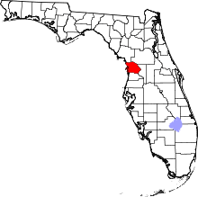 | |
| CDPs | ||
| Unincorporated communities |
| |
| Ghost town | ||