Sugarloaf (Christchurch)
| Sugarloaf communications tower | |
|---|---|
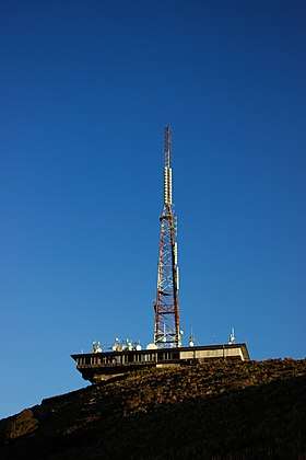 The Sugarloaf communications tower as viewed from the car park below. | |
| Highest point | |
| Elevation | 493.78 m (1,620.0 ft) |
| Coordinates | 43°36′12″S 172°38′58″E / 43.603244°S 172.649534°ECoordinates: 43°36′12″S 172°38′58″E / 43.603244°S 172.649534°E |
| Geography | |
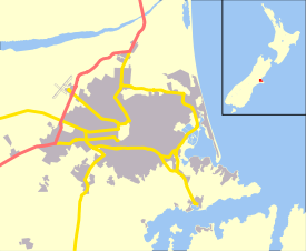 Sugarloaf Location of Sugarloaf in Christchurch, New Zealand | |
| Location | Christchurch, New Zealand |
| Geology | |
| Mountain type | Basalt volcanic rock |
The Sugarloaf is a landmark in the Port Hills to the south of the city Christchurch. The Sugarloaf communications tower is an iconic radio and television transmission mast located on top of the hill.
Geography
The tower is situated at an elevation of 493.78 m on the top of the Port Hills, near Dyers Pass. This area is officially known as Sugarloaf Scenic Reserve. This reserve land occasionally doubles as a sheep farm and includes a car park lookout point for general public use.
Communications tower
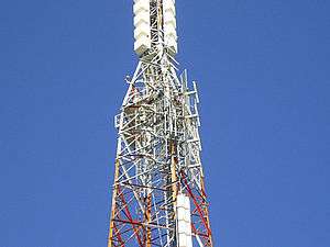
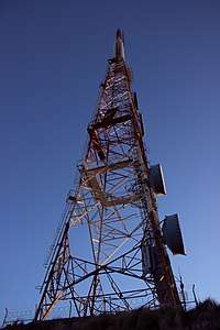
In 1965 the New Zealand Broadcasting Corporation (now known as Television New Zealand) leased a 4.9ha section of the reserve from the Crown on the summit of Sugarloaf Hill and installed the communications tower and control building. With a height of 121 m, the lattice steel structured tower is founded on a 5-metre deep concrete pad underlain by basalt volcanic rock. It is situated approximately 50 m behind the main transmission building, which combined with the tower is visible from most parts of Christchurch city.
Visual appearance
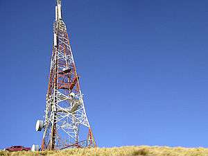
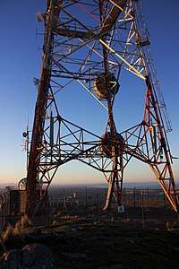
At a closer glance, the red and white tower includes an array of antennas including parabolic dishes, dipoles and microwave links. The tower has three main service decks for authorised technicians only with access ladders that run vertically along the eastern side. At night the tower is illuminated with three red beacons which span across the mast from top to bottom. On a clear night and viewed from the city you can often see the beacons and some fluorescent lighting coming from a room inside transmission house.
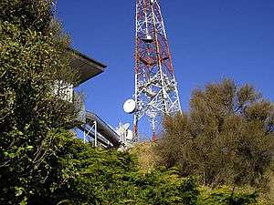
Transmission house
The tower is located 50 m behind a single storey transmission building which houses multiple transmission gear. The main equipment room is fully air conditioned and known to local technicians as the great transmitter hall. The building is approximately 40 m in width and 20 m in depth. On the roof of this building there are several satellites, small antennae and multiple parabolic dishes for private WiFi networks. There are two main shielded cable runs that go between the transmission house and back to the tower. This building has been unmanned for several years.
Site access
The entire transmission site is surrounded by a mesh security fence and a continuous hedge mixed with foliage. Access to the tower is highly restricted to authorised personnel only and climbing the tower is strictly prohibited. Vehicle access to the actual site itself is restricted via a locked gate, however there is a car park lookout point located 200m in front of the tower with panoramic views of Canterbury. Access to this reserve is permitted to the general public until approximately 6:00PM. After this time the gate between Summit Road and Service Lane is locked until the following morning.
Technical aspects
There are six main antennas that transmit TV and FM signals in the 45 MHz to 800 MHz range. The composite total power fed to all of the transmitting antennas is approximately 64 kW while the antenna gain values range from 7.8 to 16.5 dBd. Multiple services operate off the tower including television, radio, emergency response, aviation, cellular and other data signals.
The tower covers much Christchurch and central Canterbury, for example the DVB-T signal reaches as far as Waipara in the north, the foothills of the Southern Alps in the west, and the Rangitata River in the south.[1] However, not all of the central Canterbury region is covered by this tower. The nearby township of Akaroa (and most of the settlements near Akaroa) have limited to non-existent TV reception and variable radio reception. This long term problem could be solved by the construction of a second tower at least 10 km away from Sugarloaf Mountain, but it is unclear if this option has ever been given technical consideration. Likewise, the Christchurch suburbs of Redcliffs and Sumner have limited coverage from Sugarloaf, with radio (and formerly analogue television) provided through a low-power repeater in the suburb of Southshore.
Transmission frequencies
The following table contains television and radio frequencies currently operating at Sugarloaf:
| TV Channel | Transmit Channel | Transmit Frequency | Band | ERP (kW) |
|---|---|---|---|---|
| World TV digital | 28 | 530 MHz | UHF | 50, horizontal |
| MediaWorks digital | 32 | 562 MHz | UHF | 50, horizontal |
| TVNZ digital | 34 | 578 MHz | UHF | 50, horizontal |
| Kordia digital | 36 | 594 MHz | UHF | 50, horizontal |
| Maori TV digital | 38 | 610 MHz | UHF | 50, horizontal |
| Radio Station | Transmit Channel | Transmit Frequency | Band | ERP (kW) |
| The Edge | 88.9 MHz | VHF | 32, mixed | |
| RNZ Concert | 89.7 MHz | VHF | 80, mixed | |
| Tahu FM | 90.5 MHz | VHF | 16, mixed | |
| ZM | 91.3 MHz | VHF | 80, mixed | |
| More FM | 92.1 MHz | VHF | 80, mixed | |
| The Sound | 92.9 MHz | VHF | 50, slant | |
| The Rock | 93.7 MHz | VHF | 80, mixed | |
| The Breeze | 94.5 MHz | VHF | 32, mixed | |
| Mai FM | 95.3 MHz | VHF | 32, mixed | |
| Basement 96.1 (New Zealand Broadcasting School) |
96.1 MHz | VHF | 16, mixed | |
| Plains FM | 96.9 MHz | VHF | 5, slant | |
| The Hits | 97.7 MHz | VHF | 80, mixed | |
| Radio Live | 99.3 MHz | VHF | 32, mixed | |
| Newstalk ZB | 100.1 MHz | VHF | 5, mixed | |
| RNZ National | 101.7 MHz | VHF | 16, mixed | |
| Niu FM | 104.1 MHz | VHF | 16, mixed | |
| Radio Hauraki | 106.5 MHz | VHF | 16, mixed |
Former analogue television frequencies
The following frequencies were used until 28 April 2013, when Sugarloaf switched off analogue broadcasts.[2]
| TV Channel | Transmit Channel | Transmit Frequency | Band | Power (kW) |
|---|---|---|---|---|
| TV One | 3 | 62.2396 MHz | VHF | 320 |
| TV3 | 6 | 189.2604 MHz | VHF | 500 |
| TV2 | 8 | 203.25 MHz | VHF | 630 |
| Four | 11 | 224.239575 MHz | VHF | 250 |
| CTV | 44 | 655.25 MHz | UHF | 25 |
| Maori Television | 46 | 671.2604 MHz | UHF | 320 |
| Prime | 62 | 799.25 MHz | UHF | 320 |
Case Studies
An RF emissions report conducted on 9 February 1998 by the National Radiation Laboratory found that maximum exposure levels of 8 μW/cm2 were detected in the car park area, immediately below the Sugar Loaf antenna. This is 4% of the maximum of 200 μW/cm2 specified for public exposure levels in NZS 6609.1:1990. As the distance from the antenna increased, the exposure levels decreased markedly and, in general, were below 2 μW/cm2. The report concluded that the site is operating in accordance with NZS 6609.1:1990.
Gallery

Management
The tower and building are currently owned and maintained by Kordia, previously known as Broadcast Communications Limited (BCL NZ).
References
- ↑ "Likely Coverage of Freeview Aerial (DTT) Service" (PDF). Kordia. March 2008. Retrieved 14 July 2013.
- ↑ "New Zealand Television Tramsmission Stations in Operation -- South Island" (PDF). Kordia. March 2008. Retrieved 16 July 2013.
External links
| Wikimedia Commons has media related to Sugarloaf (Christchurch). |
- Sugarloaf Communications Tower as seen in Google Maps
- Panorama View from Sugarloaf Scenic Reserve
- Kordia Limited
- Christchurch City Council Reserve Information
- Port Hills Visitor Information
- Digital Switch Over Information for New Zealand
- 1998 RF Emissions Report for The Sugarloaf Communications Tower (Adobe PDF Format)
- 2005 Tower Upgrade Contract (Adobe PDF Format)
- Sugarloaf Scenic Reserve Dog Control Map (Adobe PDF Format)
- Sugarloaf Freeview coverage
- Cashmere Spur and Bowenvale Valley Reserves (Adobe PDF Format)