Stukely-Sud, Quebec
| Stukely-Sud, Canada | |
|---|---|
| Village municipality | |
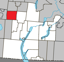 Location within Memphrémagog RCM. | |
 Stukely-Sud, Canada Location in southern Quebec. | |
| Coordinates: 45°19′N 72°25′W / 45.317°N 72.417°WCoordinates: 45°19′N 72°25′W / 45.317°N 72.417°W[1] | |
| Country |
|
| Province |
|
| Region | Estrie |
| RCM | Memphrémagog |
| Constituted | September 14, 1935 |
| Government[2][3] | |
| • Mayor | Gérald Allaire |
| • Federal riding | Brome—Missisquoi |
| • Prov. riding | Orford |
| Area[2][4] | |
| • Total | 63.80 km2 (24.63 sq mi) |
| • Land | 63.24 km2 (24.42 sq mi) |
| Population (2011)[4] | |
| • Total | 999 |
| • Density | 15.8/km2 (41/sq mi) |
| • Pop 2006-2011 |
|
| • Dwellings | 522 |
| Time zone | UTC−5 (EST) |
| • Summer (DST) | UTC−4 (EDT) |
| Postal code(s) | J0E 2J0 |
| Area code(s) | 450 and 579 |
| Highways |
|
| Website |
www |
Stukely-Sud is a village of 950 people, part of the Memphrémagog Regional County Municipality in the Estrie region of Quebec.
Demographics
Population
Population trend:[5]
| Census | Population | Change (%) |
|---|---|---|
| 2011 | 999 | |
| 2006 | 941 | |
| 2001 | 965 | |
| 1996 | 882 | |
| 1991 | 754 | N/A |
Language
Mother tongue (2011)[4]
| Language | Population | Pct (%) |
|---|---|---|
| French only | 830 | 83.4% |
| English only | 140 | 14.1% |
| Both English and French | 10 | 1.0% |
| Non-official languages | 15 | 1.5% |
See also
References
- ↑ Reference number 60928 of the Commission de toponymie du Québec (in French)
- 1 2 Ministère des Affaires municipales, des Régions et de l'Occupation du territoire: Stukely-Sud
- ↑ Parliament of Canada Federal Riding History: BROME--MISSISQUOI (Quebec)
- 1 2 3 2011 Statistics Canada Census Profile: Stukely-Sud, Quebec
- ↑ Statistics Canada: 1996, 2001, 2006, 2011 census
Adjacent Municipal Subdivisions | |
|---|---|
| Cities & Towns | |
|---|---|
| Municipalities | |
| Townships | |
| Villages | |
| |
This article is issued from
Wikipedia.
The text is licensed under Creative Commons - Attribution - Sharealike.
Additional terms may apply for the media files.