Saint-Benoît-du-Lac
| Saint-Benoît-du-Lac | |
|---|---|
| Municipality | |
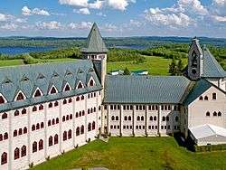 The abbey at Saint-Benoît-du-Lac. | |
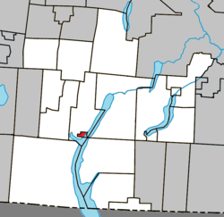 Location within Memphrémagog RCM. | |
 St-Benoît-du-Lac Location in southern Quebec. | |
| Coordinates: 45°10′N 72°16′W / 45.167°N 72.267°WCoordinates: 45°10′N 72°16′W / 45.167°N 72.267°W[1] | |
| Country |
|
| Province |
|
| Region | Estrie |
| RCM | Memphrémagog |
| Constituted | March 16, 1939 |
| Government[2][3] | |
| • Administrator | Père André Laberge |
| • Federal riding | Brome—Missisquoi |
| • Prov. riding | Orford |
| Area[2][4] | |
| • Total | 2.40 km2 (0.93 sq mi) |
| • Land | 2.38 km2 (0.92 sq mi) |
| Population (2011)[4] | |
| • Total | 50 |
| • Density | 21.0/km2 (54/sq mi) |
| • Pop 2006-2011 |
|
| • Dwellings | 0 |
| Time zone | UTC−5 (EST) |
| • Summer (DST) | UTC−4 (EDT) |
| Postal code(s) | J0B 2M0 |
| Area code(s) | 819 |
| Highways | No major routes |
| Website |
www |
Saint-Benoît-du-Lac is a community of 50 people, part of the Memphrémagog Regional County Municipality in the Eastern Townships region of Quebec. It only comprises an abbey, a cheese making facility, and its immediate surrounding lands.
Demographics
Population
Population trend:[5]
| Census | Population | Change (%) |
|---|---|---|
| 2011 | 50 | |
| 2006 | 48 | |
| 2001 | 47 | |
| 1996 | 53 | |
| 1991 | 57 | N/A |
Language
Mother tongue (2011)[4]
| Language | Population | Pct (%) |
|---|---|---|
| French only | 40 | 72.7% |
| English only | 10 | 18.2% |
| Non-official languages | 5 | 9.1% |
See also
References
- ↑ Reference number 55736 of the Commission de toponymie du Québec (in French)
- 1 2 Ministère des Affaires municipales, des Régions et de l'Occupation du territoire: Saint-Benoît-du-Lac
- ↑ Parliament of Canada Federal Riding History: BROME--MISSISQUOI (Quebec)
- 1 2 3 2011 Statistics Canada Census Profile: Saint-Benoît-du-Lac, Quebec
- ↑ Statistics Canada: 1996, 2001, 2006, 2011 census
External links
Adjacent Municipal Subdivisions | ||||||||||
|---|---|---|---|---|---|---|---|---|---|---|
| ||||||||||
| Cities & Towns | |
|---|---|
| Municipalities | |
| Townships | |
| Villages | |
| |
This article is issued from
Wikipedia.
The text is licensed under Creative Commons - Attribution - Sharealike.
Additional terms may apply for the media files.