Stratford Municipal Airport
| Stratford Municipal Airport | |||||||||||||||
|---|---|---|---|---|---|---|---|---|---|---|---|---|---|---|---|
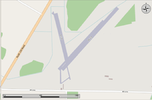 Map of the airport | |||||||||||||||
| Summary | |||||||||||||||
| Airport type | Public | ||||||||||||||
| Operator | Corp. of the City of Stratford | ||||||||||||||
| Location | Stratford, Ontario | ||||||||||||||
| Time zone | EST (UTC−05:00) | ||||||||||||||
| • Summer (DST) | EDT (UTC−04:00) | ||||||||||||||
| Elevation AMSL | 1,211 ft / 369 m | ||||||||||||||
| Coordinates | 43°24′57″N 080°56′03″W / 43.41583°N 80.93417°WCoordinates: 43°24′57″N 080°56′03″W / 43.41583°N 80.93417°W | ||||||||||||||
| Map | |||||||||||||||
 CYSA Location in Ontario | |||||||||||||||
| Runways | |||||||||||||||
| |||||||||||||||
|
Source: Canada Flight Supplement[1] | |||||||||||||||
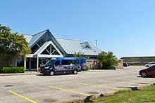
Terminal Building
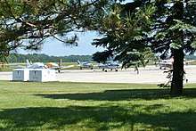
Apron
Stratford Municipal Airport, (ICAO: CYSA), is located 2 nautical miles (3.7 km; 2.3 mi) northeast of the city of Stratford, Ontario, Canada. Its location identifier designation was changed from CNM4 to CYSA effective 20 September 2012.
The airport is classified as an airport of entry by Nav Canada and is staffed by the Canada Border Services Agency (CBSA). CBSA officers at this airport can handle general aviation aircraft only, with no more than 15 passengers.[1]
References
- 1 2 Canada Flight Supplement. Effective 0901Z 19 July 2018 to 0901Z 13 September 2018.
External links
- Page about this airport on COPA's Places to Fly airport directory
| By name | |
|---|---|
| By location indicator | |
| By province/territory | |
| By area | |
| National Airports System | |
| Related | |
| |
This article is issued from
Wikipedia.
The text is licensed under Creative Commons - Attribution - Sharealike.
Additional terms may apply for the media files.