Storozhynets Raion
| Storozhynets Raion Сторожинецький район (in Ukrainian) Raionul Storojineţ (in Romanian) | |||
|---|---|---|---|
| Raion | |||
| |||
 | |||
| Coordinates: 48°7′5″N 25°37′44″E / 48.11806°N 25.62889°ECoordinates: 48°7′5″N 25°37′44″E / 48.11806°N 25.62889°E | |||
| Country |
| ||
| Region |
| ||
| Established | 1940 | ||
| Admin. center | Storozhynets | ||
| Subdivisions |
List
| ||
| Government | |||
| • Governor | N/A | ||
| Area | |||
| • Total | 1,160 km2 (450 sq mi) | ||
| Population | |||
| • Total | 99,530 | ||
| • Density | 86/km2 (220/sq mi) | ||
| Time zone | UTC+2 (EET) | ||
| • Summer (DST) | UTC+3 (EEST) | ||
| Postal index | 604XX | ||
| Area code | 380-3735X | ||
| Website | [?] | ||
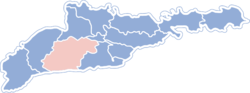
Storozhynets Raion (Ukrainian: Сторожинецький район, Romanian: Raionul Storojineţ) is a raion (administrative district) in Chernivtsi Oblast, (province) in the southwest of Ukraine. The administrative center of the raion is the town of Storozhynets. It borders with Romania from south, Vyzhnytsia Raion from west, Kitsman Raion from north, municipality of Chernivtsi and Hlyboka Raion from east. Population: 99,530 (2015 est.)[1]
According to the 2001 Ukrainian Census, the raion's population was 95,295. The ethnic composition of the district's population as reported by the census: 56,786 Ukrainians, 35,095 Romanians, 1,367 Russians, 307 Moldovans, and 1,740 other.
The Romanian population is concentrated in the south of the raion, especially around the town of Krasnoilsk (Romanian: Crasna).
The raion has 1 city (Storozhynets), 1 urban-type settlement (Krasnoilsk), 24 communes (selsoviets), and 13 villages attached to communes. These villages are
- Banyliv Pidhirnyi (Romanian: Bănila pe Siret, Bănila Moldovenească between 1922–1944, German: Augustendorf)
- Bobivtsi (Romanian: Bobești)
- Novi Broskivtsi (Romanian: Broscăuții Noi, German: Broschkoutz Neu)
- Stari Broskivtsi (Romanian: Broscăuții Vechi, German: Broschkoutz Alt)
- Budenets (Romanian: Budineț, German: Budinetz, has Romanian majority)
- Kamiana (Romanian: Camena, German: Kamena)
- Cheresh (Cireș, German: Cziresz, has Romanian majority)
- Chudei (Romanian: Ciudei, German: Czudyn, Mezhirechye between 1944–1995, has Romanian majority)
- Komarivtsi (Romanian: Comărești)
- Kostintsi (Romanian: Costești, German: Kostestie)
- Stara Krasnoshora (Romanian: Crăsnișoara Veche, Polish: Stara Huta Krasna, German: Althütte, former Ukrainian: Altkhyute between 1775–1918, has Polish majority)
- Velykyi Kuchuriv (Romanian: Cuciurul Mare, Romanian: Kuczurmare, Polish: Kuczurów Wielki)
- Davydivka (Romanian: Davideni, German: Dawideny)
- Yizhivtsi (Romanian: Igești, German: Idzestie, has Romanian majority)
- Stara Zhadova (Romanian: Jadova, German: Zadowa Alt)
- Mykhalcha (Romanian: Mihalcea, German: Mihalcze)
- Panka (Romanian: Panca, German: Panka)
- Nyzhni Petrivtsi (Romanian: Pătrăuții de Jos, German: Unter Petroutz, Polish: Pietrowce Dolne, has Romanian majority)
- Verkhni Petrivtsi (Romanian: Pătrăuții de Sus, German: Ober Petroutz, has Romanian majority)
- Ropcha (Romanian: Ropcea, has Romanian majority)
- Sloboda-Komarivtsi (Romanian: Slobozia Comăreștilor, German: Komarestie Slobodzia)
- Sniachiv (Romanian: Sneci, Polish: Sniacziw)
- Tysovets (Romanian: Tișăuți, German: Teschoutz)
- Zrub-Komarivskyi (Romanian: Trei Movile)
- Arshytsia (Romanian: Arșița, has Romanian majority)
- Kabivtsi (Romanian: Căbești, German: Kabestie)
- Kosovanka (Romanian: Cosovanca)
- Nova Kranoshora (Romanian: Crăsnișoara Nouă, German: Neuhütte, has Romanian majority)
- Dubove (Romanian: Dubova)
- Dibrivka (Romanian: Dumbrava)
- Hlybochok (Romanian: Hlibacioc)
- Hodyliv (Romanian: Hodilău)
- Nova Zhadova (Romanian: Jadova Nouă, German: Zadowa Alt)
- Spaska (Romanian: Spasca)
- Ursoia (Romanian: Ursoaia, Usole between 1944–1995, has Romanian majority)
- Zabolottia (Romanian: Zabolotie, Yablonovets between 1944–1995)
- Zavoloka (Romanian: Zavoloca)
References
- ↑ "Чисельність наявного населення України (Actual population of Ukraine)" (PDF) (in Ukrainian). State Statistics Service of Ukraine. Retrieved 1 July 2016.
External links
- Storozhynetskyi Raion - official website (in Ukrainian)
- Verkhovna Rada website - Administrative divisions of Storozhynetskyi Raion (in Ukrainian)
| Raions | |||||
|---|---|---|---|---|---|
| Cities |
| ||||
| |||||