Putyla Raion
| Putyla Raion Путильський район | |||
|---|---|---|---|
| Raion | |||
| |||
 | |||
| Coordinates: 47°58′N 25°06′E / 47.967°N 25.100°ECoordinates: 47°58′N 25°06′E / 47.967°N 25.100°E | |||
| Country |
| ||
| Region |
| ||
| Established | 1961 | ||
| Admin. center | Putyla | ||
| Subdivisions |
List
| ||
| Area | |||
| • Total | 884 km2 (341 sq mi) | ||
| Population | |||
| • Total | 26,271 | ||
| • Density | 30/km2 (77/sq mi) | ||
| Time zone | UTC+2 (EET) | ||
| • Summer (DST) | UTC+3 (EEST) | ||
| Postal index | 591xx | ||
| Area code | 380 3738 | ||
| Website | http://www.putyla.cv.ua | ||
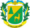
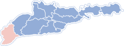
Putyla Raion (Ukrainian: Путильський район) is an administrative raion (district) in the southern part of Chernivtsi Oblast in western Ukraine, on the Romanian border. The region has an area of 884 square kilometres (341 sq mi). The administrative center of the raion is the urban-type settlement of Putyla. Population: 26,271 (2015 est.)[1]
See also
References
- ↑ "Чисельність наявного населення України (Actual population of Ukraine)" (PDF) (in Ukrainian). State Statistics Service of Ukraine. Retrieved 1 July 2016.
External links
- Web page on the website of Regional State Administration (in Ukrainian)
| Raions | |||||
|---|---|---|---|---|---|
| Cities |
| ||||
| |||||
This article is issued from
Wikipedia.
The text is licensed under Creative Commons - Attribution - Sharealike.
Additional terms may apply for the media files.