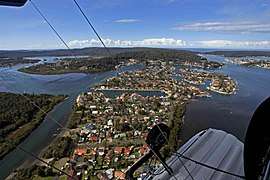
St Huberts Island, New South Wales
| St Huberts Island Central Coast, New South Wales | |||||||||||||||
|---|---|---|---|---|---|---|---|---|---|---|---|---|---|---|---|
 | |||||||||||||||
| Population | 1,058 (2016 census)[1] | ||||||||||||||
| • Density | 1,760/km2 (4,600/sq mi) | ||||||||||||||
| Postcode(s) | 2257 | ||||||||||||||
| Area | 0.6 km2 (0.2 sq mi) | ||||||||||||||
| Location | 5 km (3 mi) E of Woy Woy | ||||||||||||||
| LGA(s) | Central Coast Council | ||||||||||||||
| Parish | Kincumber | ||||||||||||||
| State electorate(s) | Terrigal | ||||||||||||||
| Federal Division(s) | Robertson | ||||||||||||||
| |||||||||||||||
St Huberts Island is a canal estate and suburb of the Central Coast region of New South Wales, Australia connected to the mainland at Daleys Point. It is part of the Central Coast Council local government area.
The modern-day development of St Huberts Island happened when Hooker-Rex Developments (now LJ Hooker Realty) built residential developments on the site in the early-1970s (https://web.archive.org/web/20070829195352/http://www.gosford.nsw.gov.au/library/local_history/Suburbs/documents/davistown-a-brief-history)
The population of the suburb recorded at the 2016 census was 1,058.
References
- ↑ Australian Bureau of Statistics (27 June 2017). "St Huberts Island". 2016 Census QuickStats. Retrieved 30 November 2017.

This article is issued from
Wikipedia.
The text is licensed under Creative Commons - Attribution - Sharealike.
Additional terms may apply for the media files.