Blackwall, New South Wales
| Blackwall Central Coast, New South Wales | |||||||||||||||
|---|---|---|---|---|---|---|---|---|---|---|---|---|---|---|---|
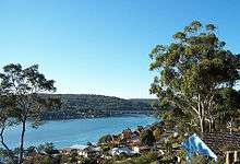 Rip Bridge from Blackwall Mountain | |||||||||||||||
| Population | 1,738 (2011 census)[1] | ||||||||||||||
| • Density | 1,450/km2 (3,750/sq mi) | ||||||||||||||
| Postcode(s) | 2256 | ||||||||||||||
| Area | 1.2 km2 (0.5 sq mi) | ||||||||||||||
| Location | |||||||||||||||
| LGA(s) | Central Coast Council | ||||||||||||||
| Parish | Patonga | ||||||||||||||
| State electorate(s) | Gosford | ||||||||||||||
| Federal Division(s) | Robertson | ||||||||||||||
| |||||||||||||||
Blackwall is a suburb of the Central Coast region of New South Wales, Australia, south of Woy Woy on Brisbane Water, 81 kilometres (50 mi) north of the Sydney CBD. It is part of the Central Coast Council local government area.
The suburb includes a boat ramp and a bushland recreation reserve, Kitchener Reserve, offering walk trails and views from Blackwall Mountain. The section of the suburb east of Kitchener Park is locally known as Orange Grove.
References
- ↑ "2011 Census QuickStats - Blackwall". Australian Bureau of Statistics. Retrieved 25 February 2017.
This article is issued from
Wikipedia.
The text is licensed under Creative Commons - Attribution - Sharealike.
Additional terms may apply for the media files.