Bouddi, New South Wales
| Bouddi Central Coast, New South Wales | |||||||||||||||
|---|---|---|---|---|---|---|---|---|---|---|---|---|---|---|---|
 | |||||||||||||||
| Postcode(s) | 2251 | ||||||||||||||
| Location | |||||||||||||||
| LGA(s) | Central Coast Council | ||||||||||||||
| Parish | Kincumber | ||||||||||||||
| State electorate(s) | Terrigal | ||||||||||||||
| Federal Division(s) | Robertson | ||||||||||||||
| |||||||||||||||
Bouddi is a coastal south-eastern suburb of the Central Coast region of New South Wales, Australia. It is in the Central Coast Council local government area. Bouddi is the Aboriginal word for the heart.[1]
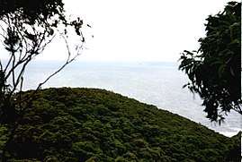
The Bouddi area locally refers to the Bouddi Peninsula and the associated suburbs of Killcare, Killcare Heights, Hardys Bay, Pretty Beach, Wagstaffe and Macmasters Beach. All of these suburbs/villages fringe the wonderful Bouddi National Park that includes Maitland Bay.
See also
Notes
- ↑ Bennett p17
References
- Bennett, F. C., ed. (1981). The Story of the Aboriginal People of the Central Coast of New South Wales. Brisbane Water Historical Society and The Entrance and District Historical Society (Jointly).
Coordinates: 33°31′05″S 151°24′00″E / 33.518°S 151.400°E
This article is issued from
Wikipedia.
The text is licensed under Creative Commons - Attribution - Sharealike.
Additional terms may apply for the media files.